Costa Blanca

Costa Blanca

To precisely geolocate this site. Update if necessary.

Localisation

Costa Blanca
LatitudeLongitude
DMS------
DM------
DD------

Characteristics

Coast

Description

The Costa Blanca  refers to over 200 kilometres of Mediterranean coastline in the Alicante province and lies until Costa Càlida, from Cabo de la Nao to Cabo de Palos.

The Costa Blanca is located on the mediterranean shore, with 219 km of coast with beaches, coves and cliffs. Alicante is the capital. he Costa Blanca stretches from Denia in the north to Torrevieja in the south below.

The name of the Spanish coast, The Costa Blanca (the white coast), is not as its name might imply its wonderful beaches but the flowers of fruit trees (olive, almond) that grow in this region.


Weather


The region of Calpe, Denia, Javea and Moraira, Spain, enjoys a superb climate all year round, with an average of 325 sunny days a year. The temperatures are always pleasant, even in summer, thanks to the fresh sea breezes, while the surrounding mountains protect the city from cold winds in winter.
2012/05/14
Update
Jojo
Costa Blanca
Alicante - Cartagena
2012-05-14
Update
Jojo
La Costa Blanca fait plus de 200 km de côte dans la province d'Alicante et s'étend jusqu'à la Costa Càlida, soit du Cabo de la Nao au Cabo de Palos.

La Costa Blanca se situe au bord de la mer Méditerranée, avec 219 km de littoral regorgeant de plages, de cales et de falaises. La capitale est Alicante. La côte blanche s’étire de Denia au nord jusqu’en dessous de Torrevieja au sud.

Le nom de cette côte espagnole, la côte blanche, ne vient pas comme son nom pourrait l’indiquer de ses merveilleuses plages mais des fleurs de ses arbres fruitiers (oliviers, amandiers) qui poussent dans cette région.


Météo


La région de Calpe, Denia, Javea et Moraira, en Espagne, bénéficie d’un climat superbe toute l’année, avec une moyenne de 325 jours de soleil par an. Les températures sont toujours agréables, même en été, grâce aux fraîches brises de mer, tandis que les montagnes environnantes protègent la ville des vents froids, l’hiver.
2012/05/14
Update
Jojo
Ebook

Espagne Est - East Spain

  • 235 sites
  • 414 photos
  • publication date: 7 Jul 2023
  • .pdf file size: 180 Mb
Share your comments or photos on "Costa Blanca"

Sites around Costa Blanca

Flying distances - Direct line

Bahia de Alicante (C Blanca)

10nm
258°
Bahia de Alicante lies between Cabo de Santa Pola and Cabo de las Huerta, 10 miles NE. The town and the harbourare located N bay.
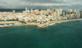
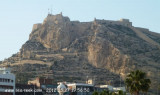
This bay is easily identified by the mountains and hills in its vicinity, and  the castle Santa Barbara, located on the top Mount Benacantil, overlooking ...
6 Jun 12
Jojo

Ensenada de Altea (C Blanca)

20nm
36°
Altea bay is located between Albir point and N the Toix cape. It offers good shelter from the winds SW to NE through W. By E wind it becomes very uncomfortable.Altea, the town, is situated 2 miles N of Punta del Albir. It is marked by a prominent church with high blue and white ...
21 May 12
Jojo

Ensenada de Benidorm (C Blanca)

13nm
31°
Ensenada de Benidorm lies between Cabezo del Tosal and Punta de la Escaleta, 3 miles E.  the small hill Canfali, which forms a promontory in the center of the cove of Benidorm, divides the coast into two splendid sandy beaches, the Levant and the Ponant.

This bay affords ...
20 May 12
Jojo

Algar de Almadraba (C Valenciana)

35nm
20°
Algar de la Almadraba, centered about 6 miles NW of Denia, is an extensive area of foul ground which lies off this stretch of coast. This area has depths of 25 to 36m and heavy seas are raised over it by onshore winds.
23 May 12
Jojo

Cabo de Las Huertas (C Blanca)

7nm
284°
The lighthouse is located on the tip of Las Huertas cape, overlooking the bay of San Juan beach.

Las Huertas Cape marks the end of the bay of Alicante, coming from the S.
20 May 12
Jojo