Altea bay is located between Albir point and N the Toix cape. It offers good shelter from the winds SW to NE through W. By E wind it becomes very uncomfortable.
Altea, the town, is situated 2 miles N of Punta del Albir. It is marked by a prominent church with high blue and white cupolas.
The shore offers some small marinas.
Numerous fish havens are located in the Ensenada de Altea.
2012/05/21
Update
Jojo
La baie d'Altea se trouve entre la pointe d'Albir et le cap Toix, au N. Elle offre un bon abri en cas de vents de SW à NE par l'W. Par vent d'E elle devient très inconfortable.
Altea, la ville, est située à 2 MN au N de la pointe del Albir. Une église proéminente est remarquable, avec sa haute coupole bleue et blanche.
La côte offre quelques petits ports de plaisance.
De nombreux parcs à poissons se trouvent dans la baie d'Altea.
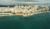
Ensenada de Benidorm lies between Cabezo del Tosal and Punta de la Escaleta, 3 miles E. the small hill Canfali, which forms a promontory in the center of the cove of Benidorm, divides the coast into two splendid sandy beaches, the Levant and the Ponant.
Algar de la Almadraba, centered about 6 miles NW of Denia, is an extensive area of foul ground which lies off this stretch of coast. This area has depths of 25 to 36m and heavy seas are raised over it by onshore winds.
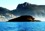
Islote de Altea lies 0.2 mile offshore, 2.5 miles NE of the harbor. A reef extends between this islet and the mainland. A dangerous wreck lies about 0.7 mile S of the islet.
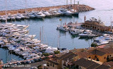
Il puerto deportivo, or Greenwich marina, is the only harbour in the world that is on the meridian
000° 00' 00'' of Greenwich, from where its name!T. 965842200F. 965842307info@marinagreenwich.com542 b. (<30 m)
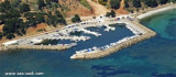
This marina islocated in front of de La Olla island, at Porto Senso, inside the Natural Park of the Sierra Helada.T. 965845944 ou 605853584F. 965845944M. : marina@portosenso.com


 Altea bay is located between Albir point and N the Toix cape. It offers good shelter from the winds SW to NE through W. By E wind it becomes very uncomfortable.
 La baie d'Altea se trouve entre la pointe d'Albir et le cap Toix, au N. Elle offre un bon abri en cas de vents de SW à NE par l'W. Par vent d'E elle devient très inconfortable.