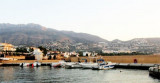
Located in Altea Bay at the bottom of the village of same name. Port of Altea homes the yacht club on the SW corner of harbor. The harbor is well protected.
T. 965842185
F. 965841579
M. cnaltea@cnaltea.com
379 b. (<30m)
Draugh: 15/20 m, bottom sand and mud.
Anchorage can be obtained, in depths of 16 to 20m, mud, 0.5 mile E of the harbor entrance.
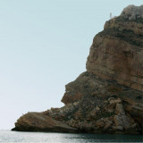
A dangerous wreck lies about 0.4 mile SSE of the harbor entrance.
On entry keep nearer to starboard side. We tried to enter and went down the middle, may have drifted just port of middle and touched bottom depth 1.9mts. 15.06.2014.
2014/06/22
Update
Situé dans la baie d'Altea au pied du village du même nom. Le port d'Altea abrite le club nautique à l'angle SW du port. Le port est bien abrité.
T. 965842185
F. 965841579
M. cnaltea@cnaltea.com
379 pl. (<30m)
Prof. 15/20 m, fond de sable et de vase.
On peut mouiller, par 16 à 20 m, à 0,5 MN à l'E de l'entrée du port.
Une épave dangereuse se trouve à environ 0,4 MN au SSE de l'entrée du port.
2012/05/21
Update
Jojo
Share your comments or photos on "Club nautico de Altea (C. valenciana)"
Sites around Club nautico de Altea (C. valenciana)
Ensenada de Benidorm lies between Cabezo del Tosal and Punta de la Escaleta, 3 miles E. the small hill Canfali, which forms a promontory in the center of the cove of Benidorm, divides the coast into two splendid sandy beaches, the Levant and the Ponant.
Algar de la Almadraba, centered about 6 miles NW of Denia, is an extensive area of foul ground which lies off this stretch of coast. This area has depths of 25 to 36m and heavy seas are raised over it by onshore winds.
This small basin offers 36 berths for small boats. During summer, it offers rental services of catamarans and windsurfing.
T. 965 840 69736 b. (<9 m)draugh: 1,5 à 2m


 Canal 9


 Located in Altea Bay at the bottom of the village of same name. Port of Altea homes the yacht club on the SW corner of harbor. The harbor is well protected.
")
")
 Situé dans la baie d'Altea au pied du village du même nom. Le port d'Altea abrite le club nautique à l'angle SW du port. Le port est bien abrité.