Ensenada de Benidorm lies between Cabezo del Tosal and Punta de la Escaleta, 3 miles E. the small hill Canfali, which forms a promontory in the center of the cove of Benidorm, divides the coast into two splendid sandy beaches, the Levant and the Ponant.
Algar de la Almadraba, centered about 6 miles NW of Denia, is an extensive area of foul ground which lies off this stretch of coast. This area has depths of 25 to 36m and heavy seas are raised over it by onshore winds.
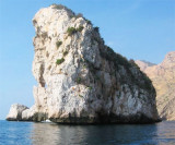
Islote Mediana (Isla Mitjana) lies close inshore, 1.5 miles NE of Punta de la Escaleta. It usually cannot be distinguished against the cliffs, except from a short distance.
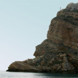
Punta de La Escaleta is is high (70 m), and carries a steep tower.
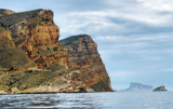
From this point, the chain of cliffs called "Sierra Helada" or "rocks Arabi" extends to the NE over a length of 3.5 NM. These reddish cliffs, which rise up to 190 m, are overlooking the sea and a gentle ...


 Above you have the Benidorm wastewater treatment plant. The nice waterfall on the coast is just polluted water. Don't swim here!!!
 Ne pas se baigner, zone de déversement des eaux usées de la station d'épuration de Benidorm.
 Cascada d'aigua bruta a la serra Gelada de Benidor.