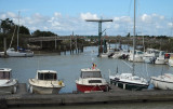
Marans PORT fluvial france 17230 Pour tous les details voir ici http://ville-de-marans.com/decouvrir/90-la-ville/86-port-de-marans?start=3http://ville-de-marans.com/index.php?view=article&catid=90%3Ala-ville&id=86%3Aport-de-marans&option=com_content&Itemid=57
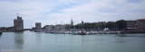
The old port, is situated on the S side of the
city at the head of an inlet. It is one of the largest coastal and
deep-sea fishing ports in France and is equipped to process fish
in considerable amounts.
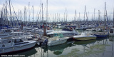
The main harbor comprises of a tidal basin, an outer wet basin,
and inner ...
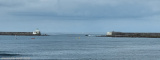
Access channel dredged to the coast -1. The axis of the channel is materialized, day and night, by the alignment at 059 ° of the two headlights: octagonal white with green top for the rear (23 m) and cylindrical with red and white bands and red top for the previous (14 m). The channel ...