Capbreton

Capbreton

To precisely geolocate this site. Update if necessary.

Localisation

Capbreton
LatitudeLongitude
DMS------
DM------
DD------

Characteristics

Port

Description

Capbreton
2012-06-24
Update
ANDI
Capbreton
2012:04:21 18:13:18
2012-06-24
Update
ANDI
Between ARCACHON and ANGLET, CAPBRETON is the only port of LANDES. Close to huge sandy beaches and the Landes forest.
The PORT OF CAPBRETON has a very privileged situation.
You are 5 minutes from the city center - 4 km - from the highway exit of the A63 BENESSE MAREMNE toll (exit No. 7). The A63 will take you directly to BIARRITZ - 20kms - and its airport which connects the main major destinations.

The docking dock is located at starboard entering the harbor next to the fishermen.

It is advisable to go back along the dike north 3h before and after the high sea. So distrust in bad weather and in times of heavy swell, a bar can then stand up to the entrance; a fortiori during the ebb tide, the current then opposing the sea. It will be necessary to wait on the gouf of Capbreton (high ground) or to turn back to Bayonne (to 2h by sailboat).

Easy entry as long as the sea is not formed but caution otherwise ...
  • 950 berths up to 23 m
  • On each site: drinking water and electricity.
  • Access to each pontoon is secured by an automated portal (electronic individual badge).
  • On each basin: toilets, showers, waste and used oil recoveries, daily weather billboard.
  • Device for assisting boarding of persons with reduced mobility (refueling station).
During the season, a taxi boat proposes to cross the harbor basin to connect Capbreton to Hossegor: "the Boucarot" (only in season).
2019/06/5
Update
azerty
il y a un gros banc de sable avant l'entrée du port  qui la rend très dangeureuse. A éviter avec de gros tirant d'eau  car le port est ensablé. 
2019/06/5
Update
azerty
Entre ARCACHON et ANGLET, CAPBRETON est le seul port des LANDES.  A proximité d’immenses plages de sable fin et de la forêt landaise.

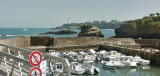
Le PORT DE CAPBRETON dispose d’une situation très privilégiée. 
Vous êtes à 5 minutes du centre ville - 4 km - dès la sortie autoroutière de l’A63 au péage de BENESSE MAREMNE (sortie n°7) . L’A63 vous conduira directement à BIARRITZ - 20kms - et son aéroport qui relie les principales grandes destinations.

Le ponton d'accueil est situé à Tribord en entrant dans le port à côté des marins pêcheurs.

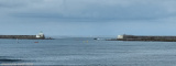
Il est conseillé de rentrer en longeant la digue nord 3h avant et après la pleine mer.  Méfiance donc par mauvais temps et en période de grosse houle, une barre pouvant alors se lever face à l'entrée ; à fortiori pendant le jusant, le courant s'opposant alors à la mer. Il conviendra d'attendre sur le gouf de Capbreton (haut fond) ou de rebrousser chemin jusqu'à Bayonne (à 2h en voilier). 

Entrée facile tant que la mer n'est pas formée mais prudence autrement...

  • 950 places à flots jusqu’à 23 m
  • Sur chaque emplacement : eau potable et électricité.
  • L’accès à chaque ponton est sécurisé par un portail automatisé (badge individuel électronique).
  • Sur chaque bassin : sanitaires, douches, récupérations déchets et huiles usagées, panneau affichage journalier de la météo.
  • Dispositif d’aide à l’embarquement des personnes à mobilité réduite (station d’avitaillement).
Durant la saison, un bateau taxi propose de traverser le bassin portuaire pour relier Capbreton à Hossegor : « le Boucarot » (uniquement en saison).
 
2019/06/5
Update
azerty
Capbreton
2019-06-05
Update
Anonymous
Ebook

Golfe de Gascogne

  • 266 sites
  • 250 photos
  • publication date: 9 Jul 2023
  • .pdf file size: 204 Mb
Share your comments or photos on "Capbreton"

Sites around Capbreton

Flying distances - Direct line

Phare de BIARRITZ

10nm
207°
This lighthouse is built from 1830 and guides the navigators since February 1st, 1834. Located on the tip of St. Martin, 75 meters above sea level, the lighthouse has a height of 47 meters. The current Fresnel lenses and catadioptric rings were installed in 1904. They scanned the ...
2 Jun 19
azerty

Port de Biarritz

11nm
207°
Charmant petit port appelé également port des pêcheurs.
2 Jun 19
azerty

Passe de l'Ouest

18nm
213°
La baie de Saint Jean de Luz est un vaste plan d'eau ouvert au Nord où les fonds présentent une faible pente. Au niveau des passes, les profondeurs atteignent -15m côté Ouest, entre les digues de Socoa et de l'Artha, et -8 à -9m côté Est, entre les digues de Sainte Barde et de l'Artha.
19 Aug 21
azerty