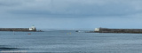
This lighthouse is built from 1830 and guides the navigators since February 1st, 1834. Located on the tip of St. Martin, 75 meters above sea level, the lighthouse has a height of 47 meters. The current Fresnel lenses and catadioptric rings were installed in 1904. They scanned the night with two 10-second flashes for a visual range of 26 nautical miles.
It has the shape of a cylindrical shaft placed on a base of two levels, originally octagonal and then enlarged in 1950 for the purposes of electrification. It is automated in 1980 and has been registered as a historic monument since November 6, 2009.
2019/06/2
Update
azerty
Phare construit entre 1830 et 1832 se trouvant à la pointe Saint-Martin qui séparre Biarritz d'Anglet..
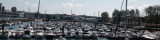
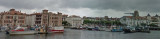
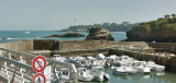
La baie de Saint Jean de Luz est un vaste plan d'eau ouvert au Nord où les fonds présentent une faible pente. Au niveau des passes, les profondeurs atteignent -15m côté Ouest, entre les digues de Socoa et de l'Artha, et -8 à -9m côté Est, entre les digues de Sainte Barde et de l'Artha.


 Phare construit entre 1830 et 1832 se trouvant à la pointe Saint-Martin qui séparre Biarritz d'Anglet..