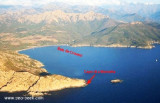
The 16 december 1810, five signal stations (La Parata; Cavallo; Capo Corse; Sagro; La Chiappa; Pertusato) are in activity in Corsica. They are equipped with powerful radar and visual powerful and armed by personnel of the French Navy.
In early 1987, Cavallo will be put to sleep and that of Ile Rousse will be closed, Alistro will be rebuilt and put back on activities in 1986-1987.
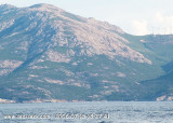
Beware at "Banc de Cavallo" that lies to a depth of 31 m and extends just over 1.8 MN from the Cape. When the sea is rough, it breaks sharply on the bench and you must navigate at least 3 NM from it.
2012/05/12
Update
Jojo
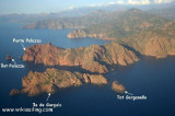
Cap Cavallo vu du N
2006:07:19 09:52:11
2012-05-12
Update
Jojo
En date du 16 décembre 1810, cinq sémaphores (La Parata; Cavallo; cap Corse; Sagro; La Chiappa; Pertusato) sont en activité en Corse. Ils sont équipés de matériel radar et visuel performant et armés par du personnel de la Marine Nationale.
Début 1987, Cavallo sera mis en sommeil et celui de l'Île Rousse sera fermé, Alistro sera reconstruit puis remis en activités en 1986-1987.
Attention au Banc de Cavallo qui s'étend à une profondeur de 31 m et s'étend à un peu plus de 1,8 MN du cap. Quand la mer est mauvaise, elle se brise fortement sur ce banc et il faut naviguer à au moins 3 MN de celui-ci.
The nature reserve, which is part of the Regional Natural Park of Corsica, occupies the Scandola peninsula, an impressive, porphyritic rock mass. The vegetation is an outstanding example of scrubland. Seagulls, cormorants and sea eagles can be found there. The clear waters, with their ...
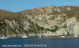
Crovani bay is limited N by Capu di Mursetta (Calenzana) and S by Punta Ferraghiola (Galeria).Noticeable bay housing one of the infrequent beaches of this area (brown pebbles beach), very dangerous by strong W wind and sea.Good anchorage S cape Cavallo, where you can drop the anchor ...
N cap CAVALLO, Nichiareto bay offers a suitable anchorage by Libeccio, but none by Mistral. It is recommended to anchor or in front of the beach by 6 to 7 m on a sandy bottom, rocks and seaweed, just in the east of the small point Bianca where protection against Libeccio ...
West of Calvi, Porto Vecchio bay, (not to be confused with the city to the south of Corsica) extends deep into the shore steep and high. It offers good shelter from the north wind in the East, but no by Libeccio. Beware of rocks, 17m high, in the southern part which ...
Capo Sagro is located at 11 NM. S Finocchiarola islands. He has a signal station and a semaphore rises N of it. Mount Merizatodio, 778 m high, is 1.5 MN to W Cape and dominates the immediate area.
The village of Erbalunga, situated 1.5 miles SSW of Capo Sagro, stands on the S ...
SW of Corsica offers some of the most beautiful anchorages. As you get closer to Bonifacio be carreful with the weather forecast as the NW wind can be very strong.
The range of the tide in this area is negligible. There are no regular currents along the coasts of Corse, ...


 The 16 december 1810, five signal stations (La Parata; Cavallo; Capo Corse; Sagro; La Chiappa; Pertusato) are in activity in Corsica. They are equipped with powerful radar and visual powerful and armed by personnel of the French Navy.
 Cap Cavallo vu du N
 En date du 16 décembre 1810, cinq sémaphores (La Parata; Cavallo; cap Corse; Sagro; La Chiappa; Pertusato) sont en activité en Corse. Ils sont équipés de matériel radar et visuel performant et armés par du personnel de la Marine Nationale.
 Cap Cavallo vu du S
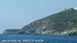
 Le vieux phare