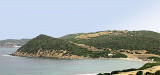
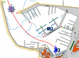
This small cove offers a sheltered ancorage. The beach is part of the Naval Base of Poglina (NATO) and it is not allowed to dock there. However, we can anchor there and watch the beach by far!
There is a small dock where the depth is 3 m for larger boats you can anchor in front of the dock, outside by 7 m.
Le Mistral, when high, causes the surf, but is not dangerous.
2012/11/15
Update
Joëlle
Cette petite anse offre un mouillage abrité. La plage fait partie de la base navale NATO de Poglina et il n'est pas autorisé d'y accoster. On peut cependant y mouiller et regarder la plage de loin!
Il existe une petit ponton où la profondeur est à 3 m, pour les plus gros bateaux on peut mouiller en face, au large du ponton par 7 m.
Le Mistral, lorsqu'il est fort, provoque du ressac, mais n'est pas dangereux.
2012/11/15
Update
Joëlle
Questa piccola cala offre un ancoraggio riparato. La spiaggia fa parte della base navale NATO di poglina ed è pertanto inaccessibile. E' possibile osservare la spiaggia solamente a distanza di sicurezza dal mare!
C'è un moletto dove la profondità è di 3 m, per le più grandi barche possono attraccare di fronte al largo del moletto di 7 m.
Le Maestral, se forte, provoca una risacca un po’ fastidiosa ma non è pericoloso.
The park begins at Capo Galera to continue toward the gulf of Porto Conte that is protected by two promontories, Punta Giglio and Capo Caccia-Monte Timidone. The marine protected area embraces the stretch of sea to the north-west of Punta Cristallo.Almost all of the park consists ...
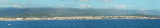
Rada di Alghero is entered between S, the town of Alghero and N, capo Galera.The E shore of this bay is low and sandy, and the W shore is hilly and rocky. An undulating coastal plain, partly under cultivation, lies immediately inland of the head of this bay.This bay is open to ...
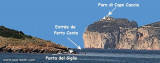
Porto Conte is a natural bay between Punta del Giglio and Caccia cape.Along E shore of the bay, on a projecting point, we see Porto Conte village, with the tower Nuova, which is backed by a turret with a light.You can anchor anywhere. The bay offers shelter from all winds. Mount ...
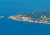
Punta Poglina is low and surmounted by the same name tower. The cape is overflowing by an islet.In about 1960, near the Poglina tower, was created a secret military base wich is still active.
Alghero is part of the "Riviera del Corallo", famous for its red corals. Beautiful city where 60% of people still speak an archaic Catalan and Italianate, the" Alguérois". Alleys, promenade along the sea on the walls. The port is divided into many concessions, so discussions!


 This small cove offers a sheltered ancorage. The beach is part of the Naval Base of Poglina (NATO) and it is not allowed to dock there. However, we can anchor there and watch the beach by far!
 Cette petite anse offre un mouillage abrité. La plage fait partie de la base navale NATO de Poglina et il n'est pas autorisé d'y accoster. On peut cependant y mouiller et regarder la plage de loin!
 Questa piccola cala offre un ancoraggio riparato. La spiaggia fa parte della base navale NATO di poglina ed è pertanto inaccessibile. E' possibile osservare la spiaggia solamente a distanza di sicurezza dal mare!
")