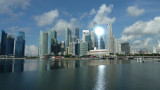
Bay dedicated to the commercial exchanges in the past. Nowdays, it is the center of the business activities and major hotels.The access from the open sea through the Marina channel is now closed and thus it's a fresh water zone due to the singapor river. On the South-East side, Marina ...
Karimun Kecil or Little Karimun, separated from the NE side of Great Karimun by a deep channel about 0.5 mile wide, is a bold island, 377m high. In the NW approach to the channel between Great Karimun and Little Karimun are two islets, Nangoi, 39m high, about 1.2 miles W of the ...
Pulau Pelanduk Subang Mas lies about 2 miles NW of Pulau Cemara.Pulau Airradja (Airaja), lies close N and is separated by a narrow drying channel at LW. It is the northernmost of the islands lying between Pulau Cemara and the E entrance of Selat Bulan.Both these islands are hilly ...


 Tourist place with a lot of fish restaurants.