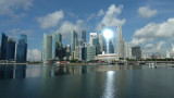
Baie autrefois très active pour le trafic de marchandise. Aujourd'hui la baie est au centre du coeur des affaires et des hôtels de Singapour.Au SE, un grand complexe Marina Bay Sands avec ses hôtels, commerces, casino et son jardin suspendu à 200m de haut au dessus de trois tours.L'accès ...
Karimun Kecil or Little Karimun, separated from the NE side of Great Karimun by a deep channel about 0.5 mile wide, is a bold island, 377m high. In the NW approach to the channel between Great Karimun and Little Karimun are two islets, Nangoi, 39m high, about 1.2 miles W of the ...
Pulau Pelanduk Subang Mas lies about 2 miles NW of Pulau Cemara.Pulau Airradja (Airaja), lies close N and is separated by a narrow drying channel at LW. It is the northernmost of the islands lying between Pulau Cemara and the E entrance of Selat Bulan.Both these islands are hilly ...


 Tourist place with a lot of fish restaurants.