Sentosa SW

Sentosa SW

To precisely geolocate this site. Update if necessary.

Localisation

Sentosa SW
LatitudeLongitude
DMS------
DM------
DD------

Characteristics

Mooring

Description

Cargos anchoring SW of Sentosa.

2010/03/12
Update
Sentosa SW
2010-03-12
Update
Anonymous
Share your comments or photos on "Sentosa SW"

Sites around Sentosa SW

Flying distances - Direct line

Pulau Tekong

16nm
55°
Small island on the east side of Singapre, close to Malaysia.Access is reserved to military activities and personnels.
17 May 11
Wikiadmin2

Pulau Karimun Kecil (E Sumatra)

26nm
257°
Karimun Kecil or Little Karimun, separated from the NE side of Great Karimun by a deep channel about 0.5 mile wide, is a bold island, 377m high.
In the NW approach to the channel between Great Karimun and Little Karimun are two islets, Nangoi, 39m high, about 1.2 miles W of the ...
1 Feb 12
Jojo

Keppel Marina

1.1nm
342°
Provide here details of the site. You can put text or images.
10 Mar 10

Marina Bay

3.4nm
46°
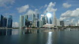
Bay dedicated to the commercial exchanges in the past. Nowdays, it is the center of the business activities and major hotels.The access from the open sea through the Marina channel is now closed and thus it's a fresh water zone due to the singapor river. On the South-East side, Marina ...
18 May 11
cdg2

Pulau Pawai

6.6nm
236°
Military zone. Restricted access.
16 Dec 09
Mega06