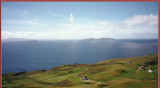
Clare Island is an island guarding the entrance to Clew Bay. The permanent population is around 120 people and the island has a shop with a post office, two bars, a restaurant, a few BnBs, a primary school and a daily ferry service to Roonagh quay. The island is the highest ...
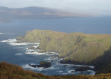
On the 11th March 1861 at midday, the lighthouse tower was
struck by the sea,l smashing 23 panes, washing some of the lamps down the
stairs, and damaging the reflectors with broken glass beyond repair. So much water cascaded down the tower that it was
impossible for the keepers ...
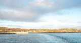
Marks the South entrance of Achill sound. The fishing harbour at Cloghmore (at the very south tip of Achill) offers good shelter in all weather, but the bar East of Achill beg may break especially on the ebb. In bad westerly weather with swell the south entrance of Achill sound is ...
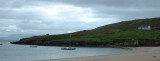
The harbour on Clare Island offers good shelter from all wind with West in them, but is completely open to Easterlies. Do not come alongside the new (outer) pier, which is used by ferries. It is possible to dry out alongside the inner pier, or indeed anywhere in the inner harbour, ...