Localisation
Banjul
Latitude Longitude DMS --- --- DM --- --- DD --- ---
Description
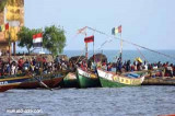
Small port .
2012/01/21
Update
transcriptlogobg
Petit port .
2012/01/21
Update
transcriptlogobg
2012-01-21
Update
transcriptlogobg
Ebook
West Africa 18 sites 8 photos publication date: 5 Aug 2024 .pdf file size: 7 Mb
Share your comments or photos on "Banjul"
Sites around BanjulFlying distances - Direct line
Dakar
Baie de Hann
Conakry
Sea-Seek Sailing Guide During your navigation, remember to update the data. If a harbor, marina or anchorage is missing, create it. Thank you for all boaters.


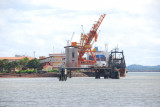
 Small port .
 Petit port .
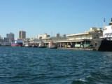