Cap d'Ail - Cap Martin
12nm
56°
Le cap Martin est couvert de pins d'où émerge un sémaphore blanc sur les hauteurs.
1 Dec 07
| Latitude | Longitude | |
| DMS | --- | --- |
| DM | --- | --- |
| DD | --- | --- |


Ebook | Côte d'Azur - French Riviera
|
 "La Baie des Anges" = The Bay of Angels is a Mediterranean bay that stretches from the city of Nice, with the Promenade des Anglais at Cap d'Antibes.
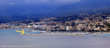
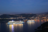
Nice-Cote d’Azur Airport in the middle is situated close E of the Var river mouth and is conspicuous at night because of its numerous lights. The S part of the airport is built on reclaimed land. The control tower and some prominent suburban houses situated behind the runways may be seen from seaward.
A prohibited area, the limits of which are shown on the chart, surrounds the seaward sides of the airport. Areas, in which vessels with superstructure heights of 4m or more above sea level are prohibited, lie at the NE and SW sides of the airport and may best be seen on the chart.
Winds
Winds from the S and SW are rare, but they sometimes blow in gusts with rain squalls and create a strong swell in the entrance channel.
Tides
Tides are almost negligible.
 La baie des Anges est largement ouverte entre la pointe du Fort Carré et le Cap de Nice à 9,3 M au NE. Elle est divisée en deux parties presque égales par l'embouchure du Var dont les alluvions ont créé une importante saillie de la côte sur laquelle est implanté l'aéroport de