
Ramen Point ( Tamil Nadu-E India)
4.8nm
6°
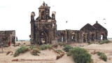
A temple in ruins lies about 183m W of the point; a coconut plantation lies about 183m farther W.
The coast from Ramen Point to Devipattanam, about 21 miles NW, is generally low and ...
23 Mar 12
Jojo
| Latitude | Longitude | |
| DMS | --- | --- |
| DM | --- | --- |
| DD | --- | --- |

 Mansfield Patch, with a least depth of 5.8m, about 7 miles SE of Kundagal Point, is the N and shallowest of a group of detached patches.
Batt Patch, with a least depth of 4.9m, lies about 2.8 miles WNW of Mansfield Patch; the sea breaks on Batt Patch in a fresh breeze.
Manauli Reef, with its E edge about 4 miles SW of Kundagal Point, consists of coral and dries in places. The E end of the reef is marked by beacons.
Manauli Tivu (Manilla Tivu), with a conspicuous white beacon close E, lies about 2 miles from the E end of the Reef.
Pulli Shoal, with a least depth of 1.2m and over which the sea breaks, lies about 3 miles E of Manauli Tivu.
Puma Channel, leading to Pamban Pass, lies between Manauli Reef and Pulli Shoal.
Pulli Reef, N of Pulli Shoal, has three islands on it.
Pumurichan, along the W edge, has a conspicuous beacon, 10m high, on its SW side; Pumurichan Tivu, farther SE; and Kurisadi Tivu (Kursadi Tivu).
The extensive coral reef dries in places; its N edge is well defined at low water, but its S edge is indented and the sea breaks on it. Beacons mark the S and NW sides of Pulli Reef.
Kurisadi Beacon No. 2, 7m high, lies in the middle of Kurisadi Tivu. Kurisadi Beacon No. 1, 4.8m high, lies about 0.2 mile NW of Kurisadi Beacon No. 2, on the N edge of Pulli Reef.
Shingle Island, low and covered with scrub, lies nearly 1 mile ESE of Kurisadi Tivu. The island lies on Kallaru Reef, a coral reef, on the SW edge of which the sea breaks heavily. A conspicuous triangular white beacon, 9.5m high with a black band, lies on the E end of Shingle Island.
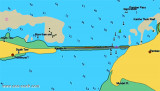
Kundagal Channel leads into Kundagal Gut, between Kundagal Point and the N side of Kurisadi Tivu, then NW into Sand Bank Channel, then NNE through The Basin to Pamban Pass.
The tidal current sets W through Kundagal Channel on the flood, and then W along the N edge of Pulli Reef, where it joins with the flood current through Puma Channel. The combined currents then set N, but they are weak unless influenced by strong S winds.
Vessels approaching Pamban Pass from the S should use great care as the off-lying islands are low, and there are no hills or conspicuous landmarks. During the Southwest Monsoon, haze frequently overhangs and obscures the islands.
Vessels over 4.6m draft should not approach within depths of 14.6m until their position is accurately determined.
The first landmarks identifiable from seaward are Rameswaram Temple, 50m high, appearing as a large square tower viewed from NE or SW and as a narrow pinnacle from SE or NW; Gandhamana Temple, 44m high, about 1 mile NW, lying in a large enclosure, but less conspicuous;
Pamban Light, a white tower, on a sandhill on the NW point of Pamban Island; a red square water tower on a framework structure, 18m high, about 5 miles W of Pamban Light, and conspicuous when bearing less than 050°; and the beacon close E of Manauli Tivu, Pumurichan, and Shingle Island.
Vessels approaching Kundagal Channel, which is the better and more direct approach, should, after having passed the outlying dangers, steer to pass about 0.4 mile E of Shingle Island, taking care to avoid the shoals E.
When the beacon about 0.3 mile NE of Kundagal Point bears 286°, steer for Kundagal Gut, passing S of Kundagal Point. Continue W and bring Kurisadi Beacon No. 1 and Kurisadi Beacon No. 2 in line, astern, bearing 130°; this range leads through Sand Bank Channel passing close SW both of a buoy, moored 0.6 mile W of Kundugal Point, and a buoy moored 0.5 mile further WNW. Keep close to beacons marking the SW side of the latter channel, and SW of Elbow Buoy, a red conical buoy at the junction of Sand Bank Channel and The Basin, a narrow channel leading NNE, with depths of 4.6 to 6.7m in the fairway, which is marked by beacons.
A NNE course through The Basin leads to the S end of Pamban Pass.
A buoy moored 0.5 mile SW of Elbow Buoy marks a shoal ground of less than 1m on the W side of the deeper water at the intersection of Sand Bank Channel and The Basin.
Puma Channel, the SW approach, only available to those with local knowledge, demands navigation by eye. Manauli Reef, on the W side, is well-marked on its S and E sides by breaking seas.
Mandapam South Beacon, in line bearing 338° with a beacon on a low hill NNW, leads into Puma Channel. When the beacon on the SW side of Pumurichan bears 060°, vessels should steer NE through Puma East Channel; then steer along the N edge of Pulli Reef and into the channel N of Pulli Reef, marked by beacons; and finally steering into Sand Bank Channel and following the directions given above.
The vessels bound for the drydock at Mandapam, about 0.5 mile E of Mandapam South Beacon, should pass through Puma Channel as described and, leaving Cana Paru Reef about 0.3 mile to port, continue on the 338° range line until 1.3 miles from Mandapam South Beacon; local knowledge is necessary from this point.
The drydock at Mandapam is 81m long and 15m wide, with the sill 2m below chart datum.
Ebook | Bay of Bengal
|