SW of Corsica offers some of the most beautiful anchorages. As you get closer to Bonifacio be carreful with the weather forecast as the NW wind can be very strong.
The range of the tide in this area is negligible. There are no regular currents along the coasts of Corse, ...
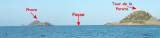
“Les îles sanguinaires” meaning the bloody Island as in the old days, a lot of ships sank and their crews where crushed on the rocky landscape of those sharp islands. There is a beautiful 1608 Geonese tower on one of the main island from this small archipelago.
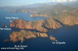
The nature reserve, which is part of the Regional Natural Park of Corsica, occupies the Scandola peninsula, an impressive, porphyritic rock mass. The vegetation is an outstanding example of scrubland. Seagulls, cormorants and sea eagles can be found there. The clear waters, with their ...


 2003-08-13
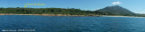
 Large anse, très ouverte entre le Cap de Feno et les Sanguinaires. Abris de beau temps uniquement.