Angola

Angola

To precisely geolocate this site. Update if necessary.

Localisation

Angola
LatitudeLongitude
DMS------
DM------
DD------

Characteristics

Coast

Description

Angola, officially the Republic of Angola  was a Portuguese colony from the 16th century to 1975.
2009/01/15
Update
anonymous
L'Angola est une ancienne colonie portugaise.
2009/01/15
Update
anonymous
Share your comments or photos on "Angola"

Sites around Angola

Flying distances - Direct line

Lobito

82nm
130°
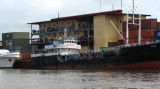
The Lobito port was built in 1928 after the Portuguese colonial authorities granted a concession to an Englishman, Sir Robert Williams. Sir Robert constructed a railway leading from Lobito deep into the heart of the continent, to transport millions of tons of copper and other minerals.
1 Feb 12
Atb

Luanda

165nm
15°
Porto de Luanda was founded by Paulo Dias de Novais in 1575 and settled by Portuguese colonists. It is the second busiest seaport in Angola.
15 Jan 09
anonymous

Port de Banana

327nm
359°
Le Port de Banana se trouve sur la rive nord de l'embouchure du Congo.
15 Jan 09
anonymous

Kipundji

334nm
358°
Kipundji ou KupundjiWhite flash every 5 seconds, visible for 15 nautical miles.
9 Dec 15
anonymous

Boma

337nm
Harbor .
12 Feb 12
altergrin

Cabinda

354nm
357°
Situation Approche
15 Jan 09
anonymous