
Pulau Tuba (Langkawi)
13nm
173°
At Pulau Tuba, you can experience ...
27 Nov 11
Jojo
| Latitude | Longitude | |
| DMS | --- | --- |
| DM | --- | --- |
| DD | --- | --- |

 2/3 m
2/3 m


")
Ebook | Andaman sea
|
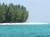
 Tanjung Rhu
has 2 choices of anchorage.
Tanjung Rhu
has 2 choices of anchorage.It can also get lumpy if winds freshen out of the West or NW.
To enter the inner anchorage, keep to the North side of channel past the sand spit and drop the hook in the immediate basin area. Beware that the spit extends out into the channel at low tide, and depths inside vary.
The inner area is protected from all winds. An interesting 3 mile ride in the dinghy is to take the SE arm which goes to "Hole In The Wall".The Tanjung Rhu Resort is worth a visit to see beautiful landscaping and enjoy a meal in luxurious surroundings.
There's also a cheaper local restaurant on the sand spit, next to the tourist clothing store.
DANGERS: Currents are extremely strong. Caution when swimming.
")
")
")
")
")