Tanjung Hele, the S point of Telokdalam, lies about 6 miles E of Teluk Lagudri. A reef marked by discolored water and very high surf, extends SE from Tanjung Hele, which should be rounded at a distance of at least 1 mile.
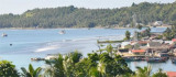
Teluk Dalam that means "Deep Gulf", is about 1 mile in length. It affords good shelter from all but SE winds, which, however, do not cause much swell, and is free from dangers. It is easily recognized by Tanjung Batu, the N entrance point, which is dark, nearly perpendicular, and ...
From Telok Dalam, the coast trends NE for about 6 miles to Tg Tedulehu (Balo Todojghu, Ujung Tedu Ichu, a low point covered with coconut trees. A number of villages lie scattered along this stretch of coast. A narrow reef fronts the shore, preventing loading in most places. With ...
Between tg Tedulehu and Ujung Sumabawa, about 11 miles N, the coast is high, with mountain ranges approaching the coast. Ujung Sumabawa is marked by a light. A low plain begins here and extends N, gradually getting wider. About 1 mile W of Ujung Sumabawa, landing may be effected ...
Makassar Reefs are four isolated dangers, with depths of 3 to 8.2m, and deep channels between them. They lie from 1.75 to 7 miles S of Sumabawa, and from 6 to 7 miles offshore. They are marked by breakers or a heavy swell.
Sirene Reefs, one of the outermost dangers in this locality, consist of four heads, of which the westernmost and the southernmost, with 0.9m of water, sometimes break; there are depths of 1.4 and 6.9m on the other two patches.


 Tanjung Hele, the S point of Telokdalam, lies about 6 miles E of Teluk Lagudri.

