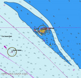

Sungai Batu Pahat (Johor - Malaysia)
1.7nm
11°
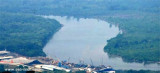
Within the entrance there are depths of 2.5 to 5m as far as the town of Batu Pahat (Bandar Penggaram), about ...
5 Jan 12
Jojo
| Latitude | Longitude | |
| DMS | --- | --- |
| DM | --- | --- |
| DD | --- | --- |

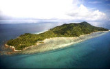
 Bukit Banang, 470m high, is the summit of a range of rolling hills which terminates at Tanjong Seginting.
Four radio masts stand on its summit. Several bright white lights, visible for a considerable distance, are sometimes shown near the radio masts.
A light is reported to be shown from Tanjung Seginting and Pulau Sialu.
The coast between Tanjong Seginting and Tanjong Piai, about 50 miles SE, is low and thickly wooded; abreast Pulau Pisang the coast recedes about 5 miles.
The coastal bank, as defined by the 10m curve, extends about 6 miles offshore in this bight and up to within 1 mile of Pulau Pisang.
Within a line joining Tanjong Seginting and Pulau Pisang the bottom is very uneven, being marked by isolated depths of 5.5 to 14.6m.
Ebook | Strait of Malacca (East)
|