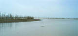

Tanjung Tanjung (E Sumatra)
29nm
177°
Tanjung Tanjung is low but can be identified by its white sandy beach and high trees.
A strong current sometimes sets here along the coastal bank. Vessels when crossing the mouth ...
23 Jan 12
Jojo
| Latitude | Longitude | |
| DMS | --- | --- |
| DM | --- | --- |
| DD | --- | --- |

 Gosong Berhala (Berhala Bank) (3°55'N., 99°26'E.), a narrow
shoal about 7 miles long with a least depth of 11m, lies centered about
31 miles NE of Tanjung Si Bunga. Good anchorage is provided on this
shoal. During the strength of the current the water is discolored and
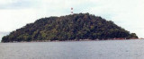
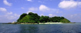
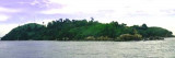
tide rips occur.Pulau Berhala (3°47'N., 99°30'E.), 177m high and thickly covered with vegetation, stands about 25 miles N of Tanjung Tanjung and is an excellent landmark. By day, the island can be seen for a distance of up to 30 miles during clear weather.
Gosong Berhala (Berhala Bank) (3°55'N., 99°26'E.), a narrow
shoal about 7 miles long with a least depth of 11m, lies centered about
31 miles NE of Tanjung Si Bunga. Good anchorage is provided on this
shoal. During the strength of the current the water is discolored and
tide rips occur.Pulau Berhala (3°47'N., 99°30'E.), 177m high and thickly covered with vegetation, stands about 25 miles N of Tanjung Tanjung and is an excellent landmark. By day, the island can be seen for a distance of up to 30 miles during clear weather.By night, with good visibility, it can be seen at a fairly safe distance. The NE and SW sides of the island are steep-to. A light is shown from the island.
A wooded islet, 48m high, stands 137m from the SE side of the island and is connected to it by a drying coral ridge. A similar rocky island, 43m high, stands about 0.5 mile NW of the island. This islet appears white in places. Between Pulau Berhala and this islet there are depths of 9 to 13m.
A rectangular area, with its center on Pulau Berhala, has been designated as a prohibited area. An ammunition dumping site lies in the SW part of this prohibited area.
Ebook | Sumatra (Indonesia)
|