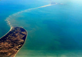
Pamban Island (also known as Rameswaram Island) is low, sandy, and well-planted with coconut trees towards its W end, where a broad peninsula extends about 3 miles N.
The chain formed by Pamban Island, the shoals of Adam's Bridge, and Mannar Island of Sri Lanka separate Palk Bay and the Palk Strait in the northeast from the Gulf of Mannar
in the southwest. Pamban Island extends for around 30 kilometres in
width from the township of Pamban in the west to the remains of Dhanushkodi
towards the south-east. The length of the island varies from 2
kilometres at the Dhanushkodi promontory to 7 kilometres near
Rameswaram. The area of the island is around 67 square km.
Adam’s Bridge (Rama's Bridge or Rama Setu) is a chain of limestone shoals of sand and rocks, mostly dry, which connects Pamban Island with Mannar Island (off the NW coast of Sri Lanka), about 16 miles ESE. It is composed mostly of shifting sand banks, with intricate shallow channels ...
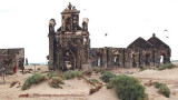
Dhanushkodi, about 2 miles NW of Lands End, is connected to the railway system of India.A pier, for use by vessels of the ferry service between Dhanushkodi and Talaimannar, extends from the NE coast of Pamban Island abreast the town. The pier is 219m long, with depths of 3.4m on each ...
Kachchaitivu (Kachchtivu), about 10 miles SW of Delft Island , is 12m high and overed with scrub. There is a well and a small shrine on the NE side of the island.Depths of less than 9.1m extend 1 mile SE of the island. Depths of less than 5.5m extend about 2.5 mile NE from the ...
Lands End is the SE extremity of Pamban Island; a small but conspicuous building lies near the point. Dhanushkodi, about 2 miles NW of Lands End, is a railroad terminal; the red-roofed railway buildings are conspicuous.
Pamban Light is shown from a conspicuous white tower on a sandhill on the NW point of Pamban Island. NE Beacon, 5.5m high and white, lies close N of the light. Kanthe Thuki Reef, composed of partly drying coral heads, lies between 0.3 and 0.5 mile W of Pamban Island Light. A ...
Pamban, administered by a conservator, lies close N of the W extremity of Pamban Island. Cargo is handled by lighters to and from the beach.South and SW winds prevail from April to October.


 Pamban Island (also known as Rameswaram Island) is low, sandy, and well-planted with coconut trees towards its W end, where a broad peninsula extends about 3 miles N.
")