Paluru to Chilka mouth (Orissa-NE India)

Paluru to Chilka mouth (Orissa-NE India)

Per individuare con precisione. Aggiornare se necessario.

Localizzazione

Paluru to Chilka mouth (Orissa-NE India)
LatitudeLongitude
DMS------
DM------
DD------

Caratteristica

Costa

Descrizione

A low beach of sand hills extends 32 miles NE from Paluru Bluff to Chilka Mouth, the entrance of Chilka Lake. There are few landmarks found along this part of the coast.

Mita Kua Bungalow, a small white house on a sand hill close to the coast about 20 miles ENE of Paluru Bluff, is the most conspicuous.

A beacon lies on the coast about 13 miles ENE of the above bluff. Sandari Beacon lies about 5 miles ENE of Mita Kua Bungalow. Babeswal Temple, painted black, lies about 2.3 miles NE of Sandari Beacon and is sometimes visible among the trees.

Chilka Lake, large shallow expanse of water, is separated from the sea by a long, narrow sandy ridge. Only boats can be accommodated.

The coast between Chilka Mouth and Puri continues low and sandy.


2012/04/19
Aggiornare
Jojo
Paluru to Chilka mouth (Orissa-NE India)
Chilka mouth
2012-04-19
Aggiornare
Jojo
Ebook

Bay of Bengal

  • 110 sites
  • 82 photos
  • publication date: 7 Jul 2023
  • .pdf file size: 53 Mb
Condividi i tuoi commenti o le foto su "Paluru to Chilka mouth (Orissa-NE India)"

Siti intorno a Paluru to Chilka mouth (Orissa-NE India)

Flying distances - Direct line

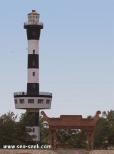
Puri lighthouse (Orissa-NE India)

30nm
73°
Puri is known internationally for Lord Jagannath temple and the annual Rath yatra. Puri is the Rail terminus providing direct trains to all major cities. The lighthouse is situated about 8 km west of Railway station.
It is a 25 m high circular tower with black and white bands, ...
19 Apr 12
Jojo

Gopalpur port (Orissa-NE India)

27nm
221°
Gopalpur is a town near Berhampur, on the shore of the Bay of Bengal. It has an ancient commercial port, now lying in ruins.
Gopalpur-on-Sea is a famous sea beach and tourist attraction. This languorous beach with coconut groves, casuarinas and gentle sand dunes is deserted for ...
18 Apr 12
Jojo

Puri port (Orissa-NE India)

31nm
73°
Puri port is an open roadstead harbor and lies on a low sandy ridge on the coast where large buildings stretch about 3 miles fronting the sea.
Harbor entrance is restricted due to tide.Puri Light is shown from a white pedestal on the wall of a two story building.
Storm signals ...
19 Apr 12
Jojo

Devi point (Orissa-NE India)

36nm
73°
Devi point is nearer  to the shakkar lake and it is at 1.5km. from Chikhaldara Busstation.
There are few steps leading to this point on the hill top, from where tourists can view the originating point of the Chandrabhaga River. Travellers can also see the ruins of the Amravati ...
21 Apr 12
Jojo

Investigator Rock (Andhra Pradeh-NE India)

52nm
219°
Investigator Rock, with a least depth of 2.3m, lies about 8.5 miles NE of Baruva South Beacon. The water over the rock is not discolored and it is not marked by breakers. A shoal area, with a least depth of 9.3m, lies 2 miles SSW of Investigator Rock.
18 Apr 12
Jojo

Paradip port (Orissa-NE India)

86nm
64°
Paradip lies on the coast about 6.5 miles ENE of the entrance of the Jatadharmhan River.
The port handles containers, general cargo, dry bulk cargo, and liquid bulk cargo.Depth—Limitations The port is approached through a channel with dredged depth of 12.8m. Vessels with a draft ...
21 Apr 12
Jojo