Devi point (Orissa-NE India)

Devi point (Orissa-NE India)

Per individuare con precisione. Aggiornare se necessario.

Localizzazione

Devi point (Orissa-NE India)
LatitudeLongitude
DMS------
DM------
DD------

Caratteristica

Relitto

Descrizione

Devi point is nearer  to the shakkar lake and it is at 1.5km. from Chikhaldara Busstation.

There are few steps leading to this point on the hill top, from where tourists can view the originating point of the Chandrabhaga River. Travellers can also see the ruins of the Amravati Fort from the top of the Devi Point.

Central Sand, a shoal with depths ranging from 0.4 to 9.1m, extends about 1.5 miles E through NE from Devi Point.
A detached 5.5m patch lies about 1.5 miles S of the same point. Central Sand is reported to have extended about 1 mile farther SE.
In fine weather, the sea does not always break over this shoal.

The Devi River, one of the largest branches of the Mahanadi River, flows into the sea N of Devi Point. This point can best be identified by Balijori Obelisk, which lies about 2.5 miles NNE of the point. Nulyasai Village is also conspicuous to approaching vessels in the vicinity of Devi Point. The river is frequented only by native craft.

Caution: A dangerous wreck is reported (2006) to lie about 11 miles offshore, about 18.5 miles ENE of Devi Point.

2012/04/21
Aggiornare
Jojo
Ebook

Bay of Bengal

  • 110 sites
  • 82 photos
  • publication date: 7 Jul 2023
  • .pdf file size: 53 Mb
Condividi i tuoi commenti o le foto su "Devi point (Orissa-NE India)"

Siti intorno a Devi point (Orissa-NE India)

Flying distances - Direct line

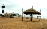
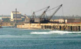
Puri port (Orissa-NE India)

4.1nm
253°
Puri port is an open roadstead harbor and lies on a low sandy ridge on the coast where large buildings stretch about 3 miles fronting the sea.
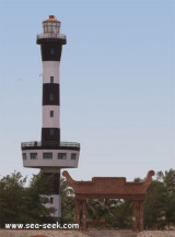
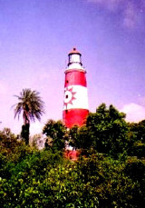
Harbor entrance is restricted due to tide.Puri Light is shown from a white pedestal on the wall of a two story building.
Storm signals ...
19 Apr 12
Jojo

Puri lighthouse (Orissa-NE India)

5.9nm
252°
Puri is known internationally for Lord Jagannath temple and the annual Rath yatra. Puri is the Rail terminus providing direct trains to all major cities. The lighthouse is situated about 8 km west of Railway station.
It is a 25 m high circular tower with black and white bands, ...
19 Apr 12
Jojo

Paradip port (Orissa-NE India)

51nm
57°
Paradip lies on the coast about 6.5 miles ENE of the entrance of the Jatadharmhan River.
The port handles containers, general cargo, dry bulk cargo, and liquid bulk cargo.Depth—Limitations The port is approached through a channel with dredged depth of 12.8m. Vessels with a draft ...
21 Apr 12
Jojo

False point (Orissa-NE India)

55nm
57°
About 2.5 miles NNE of the Lion’s Rump, False Point lies between the two entrances of the Mahanadi River and has been reported to be a good radar target up to 17 miles.
The lighthouse on the point is shown from a white round masonry tower with red bands; the lighthouse is difficult ...
21 Apr 12
Jojo

Gopalpur port (Orissa-NE India)

61nm
239°
Gopalpur is a town near Berhampur, on the shore of the Bay of Bengal. It has an ancient commercial port, now lying in ruins.
Gopalpur-on-Sea is a famous sea beach and tourist attraction. This languorous beach with coconut groves, casuarinas and gentle sand dunes is deserted for ...
18 Apr 12
Jojo

Kanika sand (Orissa-NE India)

86nm
46°
Kanika Sand, an extensive drying mud and sand flat, lies on the N side of the entrance channel about 0.8 to 5.5 miles W of Shortt Island. This flat has been reported extending to the SE.

The outer bar, which has a least depth of 1.5m, lies about 1.3 miles NNW of the middle ...
24 Apr 12
Jojo