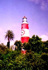
Kanika sand (Orissa-NE India)
2.9nm
25°
The outer bar, which has a least depth of 1.5m, lies about 1.3 miles NNW of the middle ...
24 Apr 12
Jojo
| Latitude | Longitude | |
| DMS | --- | --- |
| DM | --- | --- |
| DD | --- | --- |


 Palmyras Point, about 6 miles W of Shortt Island, is the N extremity of the low land which lies between the Maipura River and the Dhamra River. The point is difficult to distinguish because of the dense jungle growth which covers it. The low land on the N side of the Dhamra River presents a similar aspect as far N as Balisahi Point, about 4 miles distant.
Pilotage is not compulsory, but advisable for strangers.
The jetty at Chandbali provides berths for three small vessels with a maximum draft of 3.7m. Passengers and cargo are usually embarked and discharged alongside the jetty.
Vessels with local knowledge can anchor in mid-channel off the town of Chandbali, in depths of 8.2 to 12.2m.
Weather signals are displayed at Chandbali; the Brief System is used.
Ebook | Bay of Bengal
|