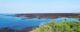
Maui, also known as the" Valley isle", for the large isthmus between its northwestern and southeastern volcanoes and the numerous large valleys carved into both mountains.
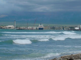
It has 120 miles of coastline for you to surf, snorkel, walk, ride,
windsurf--you get the idea. And they come in all colors: red, white,
black.
A little rolly and tricky to land at beach.
Good holding ground - big Sand patch for many boats.
Don't anchor where coral are.
Stay away if:
You want the boat don't move at all
You can't handle shorebreak
Don't like people paddle around your boat.
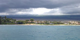
Kahului Harbor is located near the Kahului Airport and Kahului which is the islands largest town and has lots of shopping and restaurants nearby.Kahului Harbor is primarily a commercial harbor and port for Hawaii's many cruiseships such as Carnival and Norwegian Cruise Lines. Phone: ...
La perouse bay is located south of the town of Wailea. It was named for the french Captain Jean-François de Galaup, comte de La Pérouse, in 1786. La Pérouse surveyed and mapped the prominent embayment near the southern cape of Maui opposite the island of Kahoʻolawe. The ...
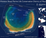
Molokini is a tiny crescent-shaped island about three miles east
of Makena.Molokini Crater is what’s left from an eruption that is said to have
occurred around 230,000 years ago. The cinder cone created has since
been eroded to a crescent atoll. Since it’s violent
volcanic ...
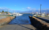
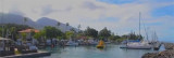
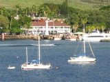
There is a marina here but you can forget it. It is always super packed and all but impossible to
get a “slip”. Just go past the marina and harbor entrance and find an open mooring buoy with
LYC painted on it. In 2010, these buoys were white and there were 7 of them. Most of them ...