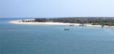
Hope Island (Andhra Pradesh-E India)
3.3nm
57°
The area between Kakinada coast and Hope Island is known as Kakinada ...
28 Mar 12
Jojo
| Latitude | Longitude | |
| DMS | --- | --- |
| DM | --- | --- |
| DD | --- | --- |

 Cocanada Bay (Kakinada Bay), a shallow body of water filled with extensive drying mud flats at its head, is entered between Godavari Point and the coast about 2.8 miles WNW.
For many years the bay has been silting up because of the discharge from the Godavari River, about 8 miles S of the entrance, but is the safest natural harbor on the E coast of the Indian subcontinent.
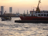
The town and port of Cocanada lie on the W side of the bay, about 2 miles within the entrance of the Cocanada River.
The low bay shores are subject to periodic inundations during cyclonic storms.
North of Cocanada, the land appears bold, with high land extending NE. South of the port, the low sandy coast is marked by some sand hills and trees.
In Cocanada Bay, the flood current sets SW and the ebb current sets NE. These tidal currents are strong at springs, especially from October to February, and must be taken into consideration when approaching in this vicinity.
Tidal current effects are noticeable nearly 0.5 mile off Godavari Point. The current follows the contour of the land, with the flood current having a maximum velocity of 0.5 knot and the ebb current having maximum velocities of 1.5 to 2 knots.
In Cocanada Bay, the flood current sets SW and the ebb current sets NE. These tidal currents are strong at springs, especially from October to February, and must be taken into consideration when approaching in this vicinity.
Tides at Cocanada are semi-diurnal.
The coastal waters in the approach to Cocanada Bay have shoaled considerably more than shown on the chart. Depths are reported to be 2.7m less than charted.
Depths S of a line drawn between Godavari Point and Vakalapudi Light to the NW shoal gradually to a depth of less than 1.8m about 4 miles to the S. Depths N and E of this line range from 7.3 to 11m, about on the meridian of Godavari Point.
Depths in the dredged buoyed channel leading to the barge facilities on the banks of the Cocanada River average about 2.1m. Depths alongside the lighter wharves range from 1.2 to 2.1m.
Ebook | Bay of Bengal
|