Fécamp

Fécamp

Per individuare con precisione. Aggiornare se necessario.

Localizzazione

Fécamp
LatitudeLongitude
DMS------
DM------
DD------

Caratteristica

Porto
VHF Canal 9
Acqua
Elettricità
Gasolio
Ristorante

Descrizione

Fécamp
2006-09-26
Bearing:90°
2007-07-11
Aggiornare
Mobile
Ebook

Manche - English Channel

  • 240 sites
  • 186 photos
  • publication date: 7 Jul 2023
  • .pdf file size: 229 Mb

Accès à toutes heures de la marée, relativement facile jusqu'à force 5 où se forment des rouleaux à l'entrée du chenal. Marina à droite du chenal, presqu'en centre ville relativement protégée des vents. La capitainerie se trouve à droite du bassin. Le ponton carburant ( 24h/24h ) est au fond du bassin à coté de l'entrée du bassin commerce.

L’escale à Fécamp est très agréable : port en centre-ville, accueil sympathique à la capitainerie, bâtiments anciens très bien conservés et entretenus dans la ville, distillerie et musée de la Bénédictine dans un bâtiment hors du commun.

Le port dispose de plus de 800 places sur pontons dont 75 sont réservées aux visiteurs  :
  • 230 places en bassin
  • 510 places en avant-port
  • 75 places pour les visiteurs en avant-port 

Contact : Sébastien BEAUFILS
Responsable du port de Fécamp
plaisance@fecamp-bolbec.cci.fr
Téléphone : 02 35 28 13 58

2012/05/5
Aggiornare
Geof
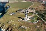
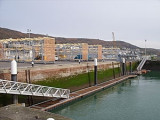
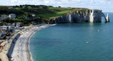
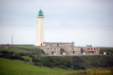
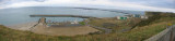
Fecamp, lying in a valley close S of Point Fagnet, is a small port with facilities for commercial vessels, fishing boats, and pleasure craft. The harbor consists of Avant-port, Arriere port, Bassin de Mi-Maree, and two non-tidal basins.

With winds from the W through N to NE, visibility is very good, and even in rainy weather, loss of visibility is only temporary.
With strong winds from the SW through N to NE, especially with an ebb current, a dangerous bar forms between the jetties, which may at times completely block the entrance. The effect of a strong swell is felt in the entrance channel, but gradually weakens in Avant-port and Arriere-port.

Winds from the ENE through S to WSW, may result in reduced visibility, especially in cold weather.

Tides at the port rise about 8.3m at MHWS and 6.8m at MHWN. Off the entrance jetties, the NNE flood current runs from about 4 hours before HW at the harbor until HW. The SSW ebb current starts about 30 minutes after HW at the harbor. The flood current may attain a rate of 2.9 knots at springs.The ebb current is weaker. At about 140m within the jetty heads, the currents flow with the channel. Both currents attain rates of 1 knot at springs and 0.5 knot at neaps.
2012/05/5
Aggiornare
Geof
Condividi i tuoi commenti o le foto su "Fécamp"

Siti intorno a Fécamp

Flying distances - Direct line

Sémaphore de Fécamp

0.3nm
24°
Histoire
En 1902, la mise en service du phare de la jetée Sud entraîne la fermeture de celui de la vierge. Le ministère de la marine décide alors d'y transférer le sémaphore. En effet, bien que jouxtant l'ancien et culminant à 104 mètre, il offre une meilleur base d'observation.
En ...
10 Nov 07

Port à sec de Fécamp

0.3nm
106°
Votre bateau est mis à l’eau à votre demande et positionné sur le ponton d’accueil qui permet une sortie en mer directe et immédiate. L’enlèvement du bateau du rack de stockage se fait à l’aide d’un chariot élévateur. Il est ensuite déposé sur un ascenseur ...
5 May 12
Geof

Etretat

7.2nm
243°
Mouillage qui mérite la visite par beau temps dans cet environnement magnifique.
Balade à pied au sommet des falaises pour avoir une superbe vue sur la baie.
5 May 12
Geof

Cap d' Antifer

9.1nm
238°
Cap d’Antifer, a prominent cape, is fronted by a steep cliff, 122m high. Cap d’Antifer Light is shown from a conspicuous tower, 38m high, standing on top of the cliffs at the cape.
The coast between this cape and Cap de la Heve, about 11 miles SSW, is formed by reddish-colored ...
5 May 12
Geof

Port du Havre-Antifer

10nm
231°
Terminal pétrolier composé de deux appontements construits à l'abri d'une digue : poste Est accessible aux navires de plus de 270 m de long et poste Ouest pour les navires de plus de 310 m de long.
27 Nov 07
Anonymous

Central Electrique de Paluel

11nm
60°
Paluel Nuclear Power Statio, with four conspicuous towers 72m high, is situated 6.5 miles ENE of Saint-Pierre-en-Port. A pylon and a water tower, both prominent, stand close SW and about 1.3 miles S, respectively, of the power station.
Two short breakwaters protect the entrance ...
5 May 12
Geof