False Bay lies between Nurrea Banga Nassi and Maipura Point, about 20 miles NE, at the entrance of the Maipura River. Depths in the bay decrease gradually toward the shore over a bottom of olive-green mud, in the S part, to a bottom of sand and mud, in the N part. The shore on the W of the bay consists of moderately-high sand hills.
Caution.—The Gahiramatha Marine Wildlife Sanctuary, best seen on the chart, lies roughly between the 10m and 20m contours in False Bay. Fishing, trawling, or any other activity harmful to marine life within this area is prohibited.
Palmyras Shoals, with depths of 2.3 to 10.1m, lie within a radius of 8 miles ENE through SE of the central part of Short Island.Caution.—Care is necessary when approaching Palmyras Shoals from the E, because the depths decrease rapidly and soundings will give no warning of the proximity ...
Kanika Sand, an extensive drying mud and sand flat, lies on the N side of the entrance channel about 0.8 to 5.5 miles W of Shortt Island. This flat has been reported extending to the SE.
The outer bar, which has a least depth of 1.5m, lies about 1.3 miles NNW of the middle ...
Palmyras Point, about 6 miles W of Shortt Island, is the N extremity of the low land which lies between the Maipura River and the Dhamra River. The point is difficult to distinguish because of the dense jungle growth which covers it. The low land on the N side of the Dhamra River ...
Balisahi Point is the extremity of the low land N of the entrance of the Dhamra River.
The coast between Balisahi Point and the entrance of the Hugli River, about 69 miles NE, is low, flat, and covered with scrub and mangroves along its S part. Southwest of Chandipur, the trees ...
Shortt Island, 3 m high, is the largest of four small islands which lie on a drying shoal about 3 miles N of Maipura Point. The configuration of the island is constantly changing due to the continuous action of the sea. A tower, 17.3m high, stands close off the E side of the island.
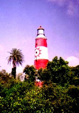
About 2.5 miles NNE of the Lion’s Rump, False Point lies between the two entrances of the Mahanadi River and has been reported to be a good radar target up to 17 miles. The lighthouse on the point is shown from a white round masonry tower with red bands; the lighthouse is difficult ...