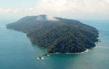
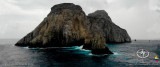
Lying to the south of Panama, Colombia Pacific coast is surrounded by Venezuela to the east, Ecuador and Peru to the south west.
Security:
Security in Colombia has improved steadily over the 2006-2008 time-frame; however, greed, corruption, drugs, and guerrillas all have their own ways ofstirring up trouble. It is best to keep an eye on the latest political climate andthe narco-trafficking/FARC information prior to entering Colombia.
Some of the poor coastal sections of Colombia, many of which are not accessible by land, can be dangerous to foreigners. The people in these areasare probably the biggest threat to cruisers.
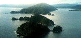
Stay away from the mangrove areas in southern Colombia from Buenaventura all the way to the border of Ecuador with exceptions of Isla Gorgona andTumaco. Avoid the area of coast between Buenaventura and Cabo Corrientes to the North.This includes the estuary north of Buenaventura.
Weather and current:
During latter months of the dry season (Nov. to May) the winds tend to blow from the N, but they will usually be light, switching to the S the further south you travel. During the rest of the year the winds tend to blow from the S to WSW and occasionally SSE.
Currents tend to run strongly most of the year from the south up to Pase Caballos at 02°27’N and 078°35’W where the Humbolt Current meets up with the counter equatorial current. Things can be choppy and confused. The current will continue to flow northwards until about Cabo Corrientes (05°30’N and 077°34’W) where it can sometimes reverse and flow south. Sometimes during January, February and April the current directions become less predictable and have even reported to reverse.
Entry/Exit officialdom:
Your Zarpe should have the name of the port you plan to enter. If you’re going to Bahia Solano, your Zarpe from your departing country should say Bahia Solano, Colombia. The same is true for Tumaco, Colombia. The officials like things to be neat and tidy. They will check the authenticity of your papers and contact your port of departure if they have any concerns. Tumaco in particular is very careful to make sure you are traveling legally and not doing anything suspicious. If your Zarpe has another port or country listed this will cause some headaches for the officials and extra paperwork. You can do it, but beprepared for some sour faces.
You are required to use an agent in Colombia, there is no way around it. They absorb all the costs (if there are any) into their fee and they will handle any issues or paperwork problems with the officials.
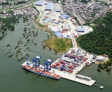
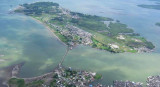
The only two ports of entry I recommend are Bahia Solano in the North and Tumaco in the South. Buenaventura is also a port of entry, however the port is a danger filled place with not much to offer the casual visitor. In an emergency Buenaventura is a safe and may be a viable option for entry and getting repairs, however it is a sketchy city.
2016/01/7
Aggiornare
Joëlle