Tumaco bay (Colombia Pacific Coast)

Tumaco bay (Colombia Pacific Coast)

Per individuare con precisione. Aggiornare se necessario.

Localizzazione

Tumaco bay (Colombia Pacific Coast)
LatitudeLongitude
DMS------
DM------
DD------

Caratteristica

Porto
Ancoraggio

Descrizione

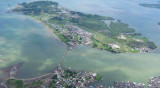
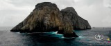
This interesting, friendly town is on the border with Ecuador. It sits on an island connected to the mainland by a causeway. Many of the houses in the area are built on stilts over the water.

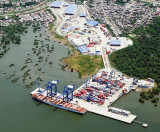
Tumaco is a military controlled port. You must call Guardacosta on VHF channel 16 when you reach the sea buoy (01° 51.80’N, 078°46.15’W). Do not proceed past this point until you have spoken with them and given them all your information and they have cleared you to enter. They will require a great number of details so have all boat paperwork and crew details to hand. It is possible to request an English translator, if necessary.

The Port Captain's office is at the Naval base and is very helpful.
Tel: 2 727 1418

Servipac is a recommended agent for clearing in. Ask the Port Captain to contact him.

The anchorage is in an estuary off the SE side of Isla del Morro, which is connected to the town by a bridge. Security is good as there is a military base on the other side of the channel. It provides complete shelter from all winds.

You will be advised where to anchor.

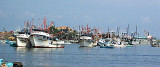
There is a commercial dock, which is not suitable for yachts.

It may be possible to use the military pier for landing with the dinghy but ensure you have permission first. Call the guards on VHF channel 71.

Alternatively, the owner of the wharf is very friendly and will allow access across his property.

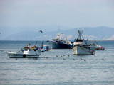
Use an anchor light at night and it is best to return to the boat by early evening. Also to ensure the boat is locked when away from it.


2016/01/7
Aggiornare
Joëlle
Tumaco bay (Colombia Pacific Coast)
2016-01-07
Aggiornare
Anonymous
Condividi i tuoi commenti o le foto su "Tumaco bay (Colombia Pacific Coast)"

Siti intorno a Tumaco bay (Colombia Pacific Coast)

Flying distances - Direct line

Tumaco (Colombia Pacific Coast)

3.1nm
76°
Tumaco, petite ville insulaire, centre de ravitaillement régional.
Important trafic de pirogues, seul moyen de transport local.Tumaco est relié par route à la Colombie; la ville dispose d'un aéroport desservi chaque jour par un DC 3; c'esdt aussi la base d'hélicos utilisés ...
8 Jan 16
Wikiadmin2

Esmeraldas

71nm
226°
Petit port .
15 May 11
RelacRicli

Buenaventura Harbor (Colombia Pacific Coast)

160nm
39°
This port is located at about the midway point in Colombia's Pacific coast. It has the reputaion of being one of the most violent cities in the country.
It's a port of entry.

Phone: 691 43 48
Fax: 691 43 52
Mail: matildec@sprbun.com

Great care needs to be ...
8 Jan 16
Joëlle

Bahia De Manta

201nm
215°
Petit port protégé par une digue.
15 May 11
rustlegg

Malpelo island

214nm
307°
Isla Malpelo is located at approximately N 3º59' W 81º36' (about 235 miles/378 km from the Columbian coast and 225 miles/362 km from Panama).
Malpelo is a world class dive spot on par with Cocos with clear water and tons of fish and sharks. Divers often see 100's of sharks ...
7 Jan 16
Joëlle