This port is located at about the midway point in Colombia's Pacific
coast. It has the reputaion of being one of the most violent cities in
the country. It's a port of entry.
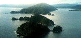
National park with a park fee and anchoring fee. There is a small military force stationed here to watch the coast. The bay offer a very good protection.
Approching, keep more than 2 NM off Punta Solano because of off lying rocks.
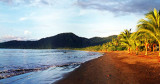
This is a Port of Entry and is a useful one if coming from Panama, being towards the north of Colombia's pacific coast.The bay is well protected but is open to the north.
There is an anchorage not ...
Just North of bahia Solano is bahia Cupica. When approching be very carefull of punta Cupica. Rocks can be found as far as two miles of the land. Bay open to the S, si it is best visited during the dry season or when the winds are coming from the North.
Tumaco, petite ville insulaire, centre de ravitaillement régional. Important trafic de pirogues, seul moyen de transport local.Tumaco est relié par route à la Colombie; la ville dispose d'un aéroport desservi chaque jour par un DC 3; c'esdt aussi la base d'hélicos utilisés ...
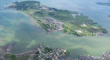
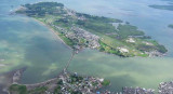
This interesting, friendly town is on the border with Ecuador. It sits
on an island connected to the mainland by a causeway. Many of the houses
in the area are built on stilts over the water.
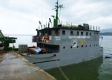
Tumaco is a military controlled port. You must call Guardacosta on VHF channel 16 ...


 This port is located at about the midway point in Colombia's Pacific
coast. It has the reputaion of being one of the most violent cities in
the country.
This port is located at about the midway point in Colombia's Pacific
coast. It has the reputaion of being one of the most violent cities in
the country.")