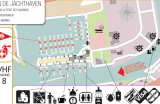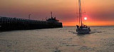

Oostende
1.5nm
313°
5 May 12
Geof
| Latitude | Longitude | |
| DMS | --- | --- |
| DM | --- | --- |
| DD | --- | --- |

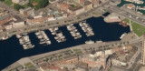
 La côte belge est le nom généralement utilisé pour désigner la partie belge du littoral de la mer du Nord. Elle s'étend sur environ 66 km de long, de La Panne à Knokke-Heist. C'est une côte très urbanisée, avec beaucoup de grands immeubles à
appartements. La côte belge compte 19 stations balnéaires.
La côte belge est le nom généralement utilisé pour désigner la partie belge du littoral de la mer du Nord. Elle s'étend sur environ 66 km de long, de La Panne à Knokke-Heist. C'est une côte très urbanisée, avec beaucoup de grands immeubles à
appartements. La côte belge compte 19 stations balnéaires.Ebook | North sea
|
 The Belgian coast extends for 36 miles between the French frontier and the Netherlands boundary, the latter situated 6 miles W of the mouth of the Westerschelde. The entire area is fronted by an extensive series of shoal banks, both detached and contiguous to the shore.