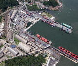
Between Pontal do Sul and Baia de Guaratuba, about 20 miles SSW, the coast is low and backed by Serra do Prata. A conspicuous water tower stands on the coast, 10 miles SW of Pontal do Sul, and a similar tower stands on Ponta de Matinhos, 2.5 miles N of the entrance to Baia de Guaratuba. At the entrance of Paranagua Bay, there are many banks and submerged and uncovered rocks in depths of less than 10m. This bay is formed by the estuaries of several rivers and is surrounded by mangrove forests. Navigation in this area should only be attempted through Galheta Channel. Galheta Channel was dredged on Galheta Bank; the depths out of its banks are less than 5m.
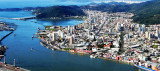
The Rio Sao Francisco do Sul flows into the sea by two mouths situated 19 and 37 miles, respectively, S of Baia de Guaratuba, and separated by Ilha de Sao Francisco. The N entrance leads to Porto de Sao Francisco do Sul on the NW side of the island. The S entrance is almost entirely ...
Itajai lies about 2 miles within the mouth of the Rio Itajai-Acu, and is entered between the heads of two moles which lie 1 mile NW of Ponta das Cabecudas, which is a good radar target for better than 20 miles. It is the main port of the state of Santa Catarina, and the second ...
Call prior to arrival. Visitors' dock. All facilities including haul out
and a boatyard with all services. Small supermarket on site. Fuel
berth. Note that the restaurant, bar, swimming pool and tennis courts
are for members only and visitors are not permitted to use these
facilities.
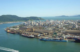
Santos lies some 230 NM SW of Rio de Janeiro and is Brazil's biggest and
most important port. The city lies partly on the island of St Vncent,
and partly on the mainland. This is not an attractive stop but useful
for repairs. The port of Santos is located in the city of Santos, ...
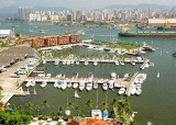
Ilhabela est une petite ville au sud est du Brésil. Elle est située sur une ile, à environ 2mile du continent.. Le climat est tropical (en général chaud avec une température moyenne de 28/30° celsius).


 Between Pontal do Sul and Baia de Guaratuba, about 20 miles SSW, the coast is low and backed by Serra do Prata.
")