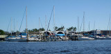

Sao Francisco do Sul (Santa Catarina)
39nm
1°
The N entrance leads to Porto de Sao Francisco do Sul on the NW side of the island. The S entrance is almost entirely ...
19 Jan 16
Joëlle
| Latitude | Longitude | |
| DMS | --- | --- |
| DM | --- | --- |
| DD | --- | --- |


 12, 14, 16


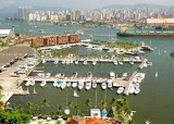
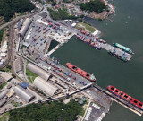
 Itajai lies about 2 miles within the mouth of the Rio Itajai-Acu, and is entered between the heads of two moles which lie 1 mile NW of Ponta das Cabecudas, which is a good
This is an official port of Entry for Brazil.
Customs, Immigration and the Port Captain are all within walking distance of the pontoon. People are friendly and willing to help. Because not many boats call here, cruisers are treated as a welcome change from everyday routine.")
Ebook | SW Atlantic Ocean
|