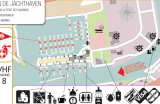
Zeebrugge hosts 2 marinas, Westhinder Marina and RYCB. The latter provides for a gas station. Marine Center Zeebrugge and Van Damme provide for maintenance shop and repair facilities. Shops nearby also some facilities for breakfast, lunch or a refreshment. Zeebrugge Port Control at VHF 71 provides for quidance into and out of the harbor. It is adviseable to check with them as the harbor is a main entrance for RORO, container ships and vessels carrying LNG.
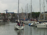
Royal Yacht Club Ostend, the oldest club of Belgium. The city of Oostende with its 9 km of sandy beaches is the biggest and most popular resort of the Belgian coast; The marina is situated at the end of the harbour and has a direct access to the sea and is always accessible whatever ...
Breskens provides for a stop-over for those who are too tired to already overtake the Westerschelde mouth crossing to Vlissingen (Flushing). Port control is accessible on VHF 14 and the harbour is accessible at all tides. Watch out for the wreck located close to the shore West to ...


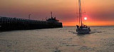
 Port de commerce protégé par une digue.
 Harbor protected by a breakwater.