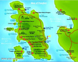
Western Anchorage is entered between Tanjong Nipah and the W extremity of Pulau Mentangor, about 1 mile SSW.A good anchorage may be obtained in Western anchorage, in a depth of about 10m, 0.25 mile WNW of Pulau Giam.
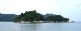
Mentangor is a large uninhabited island along S of Teluk Nipah.There were nothing worth
highlighting on the island except the scenes of rocky coast and some
tiny beaches. Next to it is the smaller, tiny Coral island with shallow water.
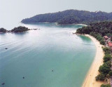
Off the coast of perak State, north of Selangor , lies a cluster of fabulous islands with unquestionably some of the best coves and beaches on the western coast of peninsular Malaysia.
Among them, two islands predominate in terms of accessibility, infrastructure and development ...
Tanjong Hantu, about 8 miles SSW of Tanjong Batu is a sloping point, the summit of which is 203m in height. The coast from Tanjong Hantu to Motts Point, the N entrance point of Dinding River, is skirted by a shallow bank having depths of less than 5.5m. The bank extends a distance ...


 Teluk Belanga, the NNW bight, afford an anchorage in the center, in a depth of 8m, shoaling gradually to the shore.
 (Malaysia)")
 (Malaysia)")