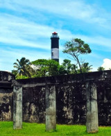
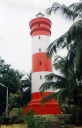
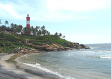
Tangasseri Point Light is shown from a concrete tower, 41m high, painted in black and white diagonal stripes, on the point. The point has been reported to be a good radar target at 17 miles.
The coast from close E of Tangasseri Point to about 3 miles NNW of it is rocky with groves of palms growing close to the HW line.
Caution: Vessels approaching Quilon (Kollam) from the N should not approach Tangasseri Point in depths of less than 20m to avoid the foul ground W and SW of the point. When the tile work’s prominent red 35m high chimney bears 044°°, steer for it on that bearing, which leads between Gamaria Rock and Pallikall Shoal.
The port of Quilon (Kollam) is a small roadstead lying in the bight close SE of Tangasseri Point. The N and S limits of the port are defined by lines extending in a 247° direction from two boundary pillars. The N pillar and the S pillar lie about 0.7 mile E and 3 miles ESE, respectively, ...
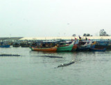
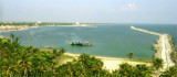
Nindakara (Neendakara) is an open roadstead port at the entrance to Ashtamudi Backwaters. At the entrance of that fishing port, two breakwaters shelter a shallow basin, with jetties on its N side where barges load ilmenite sand. The entrance can be identified from seaward by a ...
Anjengo, formerly of importance but now a fishing village, is seldom visited as its anchorage is exposed to the surf at all times. It is not easy to identify, even from a short distance, as the fort and other buildings are low and screened by trees. A light shows at a height of ...
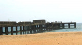
Trivandrum (Thiruvananthapuram), the capital city of the state of Kerala, lies about 1 mile from the coast. The ruins of a pier, extending to the LW line, are prominent on the coast S of the city. Trivandrum is a lighterage port with no docking facilities available.Pilotage is ...
Alleppey (Alappuzha) lies about 29 miles S of Kochi (Cochin. The coast between the ports is low, sandy, thickly fringed with palms, and densely populated. Alleppey Light is shown from a white, round, masonry tower, about 0.3 mile E of the root of Alleppey Pier. As the town of Alleppey ...
Kovalam Point (Covelong Point) is a bluff point with a conspicuous red-roofed building on it. Good radar returns have been reported from the point at 19 miles. KovalamBeach is probably the best known surf spot in India.


 Tangasseri Point Light is shown from a concrete tower, 41m high, painted in black and white diagonal stripes, on the point. The point has been reported to be a good radar target at 17 miles.
")