Tanjong Hantu, about 8 miles SSW of Tanjong Batu is a sloping point, the summit of which is 203m in height. The coast from Tanjong Hantu to Motts Point, the N entrance point of Dinding River, is skirted by a shallow bank having depths of less than 5.5m. The bank extends a distance ...
Located E coast of Pulau Pangkor in a shallow bay Port Pangkor, in front of Pangkor village, has a small jetty, with a depth of 6,1 m alongside.Tides_Currents:The flood runs S, and the ebb N along the W coast of Pulau Pangkor. taking the direction between Pulau Pangkor and Pulau Pangkor ...
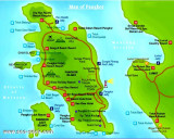
Off the coast of perak State, north of Selangor , lies a cluster of fabulous islands with unquestionably some of the best coves and beaches on the western coast of peninsular Malaysia.
Among them, two islands predominate in terms of accessibility, infrastructure and development ...


 (Malaysia)")
 It was reported that Pulau Talang, a small island off the mainland, is a good radar target up to 18 miles distance.