Nagwa Point is the S extremity of Diu Island, about 3.5 miles E of Diu Head. It is a dark bluff, with cliffs 9.1 to 12.2m high, rising to a 20m summit marked by a bush. Shoal water, over which the sea breaks occasionally, extends about 0.3 mile WSW from Nagwa Point.
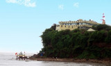
Diu Head, a rocky bluff about 30m high, can be identified by the lighthouse, two long buildings, and a small temple lying near its summit. From this summit the land slopes gradually E, terminating in a rocky point, on which there is a cairn, 8m high.
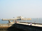
Diu Harbor, between the E end of Diu Island and the mainland N, is open E and somewhat encumbered by shoals. There are end number of forts and monuments in Diu. One of such fort and monument is Fortim-do-Mar in Diu. Located exactly at the opening of the creek, this opulent stone
structure ...
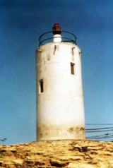
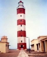
Nawabandar is a promontory situated 2 miles E of Diu Harbor; the intervening coast is high, with deep water close to it. A light is shown from a white circular building on the promontory. The town of Delvada, about 2.5 miles NW of Nawabandar, has a large conspicuous temple with twin ...
Jafarabad is an open roadstead affording little protection during the Southwest Monsoon. Theharbor is shallow and a ledge of flat rocks extends nearly 0.5 mile W from the E side of the harbor entrance. Jafarabad is a walled town, with several round towers, on the highest ofwhich ...
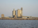
Pipavav Bandar, the principal port for Dongar, about 6 miles N, is the principal town on this part of the coast.Pipavav Bandar lies on the NW shore of the West Channel. It is an all season port offering container, bulk, break bulk and liquid cargo handling services. It imports and ...


 Nagwa Point is the S extremity of Diu Island, about 3.5 miles E of Diu Head. It is a dark bluff, with cliffs 9.1 to 12.2m high, rising to a 20m summit marked by a bush.