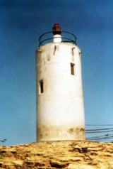

Diu Head (W India)
0nm
154°
From this summit the land slopes gradually E, terminating in a rocky point, on which there is a cairn, 8m high.
29 Feb 12
Jojo
| Latitude | Longitude | |
| DMS | --- | --- |
| DM | --- | --- |
| DD | --- | --- |


 channel 16, 71
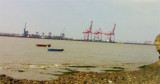
 Diu Harbor, between the E end of Diu Island and the mainland N, is open E and somewhat encumbered by shoals.
 There are end number of forts and monuments in Diu. One of such fort and monument is Fortim-do-Mar in Diu. Located exactly at the opening of the creek, this opulent stone
structure houses a light house and small chapel devoted to Our Lady of
the Sea. It is almost a nautical mile away from the Diu Jetty.
A legend holds that Panikotha or Fortim-do-Mar in Diu was once linked with land by an under sea tunnel.
The flood current S of Diu sets ENE, with a greatest velocity at springs of 1.5 knots. It often runs for 2 hours after the time of HW by the shore. The ebb current sets WSW at a velocity of 2 knots at springs, and often runs for 2.5 hours after the water along the shore has began to rise. These irregularities of tides will account in some measure for the eddy currents off Diu Head.
Diu Island is separated from the mainland by Sesalkhada Creek, which runs through the middle of a large swamp. The seaward side of the island is composed chiefly of sandstone cliffs; the hills on its W part are about 30.5m high.
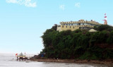
The citadel of Forte do Diu, at the E extremity of Diu Island, is conspicuous from seaward.
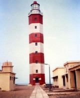
A light is shown near the center of Forte do Diu; Couraca Light is shown periodically from the NE extremity of the same fort. The town of Diu, close W of the fort, is enclosed by a wall which is breached in many places on its W sides. There are several prominent buildings in the town.
Forte do Mar is situated about 0.2 mile N of Forte do Diu, on the N side of the entrance to Sesalkhada Creek; it lies at the SE edge of a spit and is periodically marked by a light.
A temple, about 0.7 mile NNW of Forte do Mar, is conspicuous in the N part of the village of Ghoghla.
A guard house, with a red roof and a palm tree, are conspicuous about 1.3 miles NNE, and 2 miles N of Forte do Mar.
Storm signals are displayed from a flagstaff in Forte do Diu; the Brief System is used.
The port can be contacted on VHF channels 16 anf 71.
Tel: +91 287 5252263 or +91 287 5253355
Mail: diu@nic.in
Anchorage depth: 14/15,2 m
Diu Harbor affords no protection from the E; vessels should not anchor in the harbor during strong E winds, the holding ground, sand and rock.
The safest and best anchorage, in 14 to 16m, mud, lies with the light structure near the center of Forte do Diu bearing 315°, distant 0.5 to 0.6 mile. This anchorage is used by local vessels and affords protection from W winds.
There is anchorage, in 5 to 7m, about 1 mile E of Ghoghla. To reach it, vessels should steer for the temple N of Ghoghla, bearing 298°, passing between the dangers ENE of Forte do Diu, and anchoring when Couraca Light bears 240°.
A rock, with a depth of 1.3m, lies about 0.5 mile E of the E extremity of Diu Island. A 3m rocky patch lies about 0.8 mile farther ENE. A 4.7m depth lies about 1 mile ENE of the E extremity of Diu Island.
A reef, which dries in places, extends about 0.5 mile ENE from the E extremity of Diu Island.
From October to the end of January large fleets of fishing vessels based at Brancawara, at the W end of Diu Island, and also based at Diu, Nawabandar, and Simar will be found from 4 to 8 miles offshore; these vessels leave barrel buoys and logs to mark the fishing grounds, and it is advisable to give them a wide berth.
") Fortim do Mar, or Fortress of Panikota was built by the Portuguese.
Fortim do Mar, or Fortress of Panikota was built by the Portuguese.Ebook | Arabian Sea
|