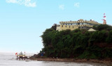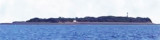

Piram island (W Cambay gulf - India)
3.3nm
120°
The lighthouse is conspicuous near the middle of the island; ...
1 Mar 12
Jojo
| Latitude | Longitude | |
| DMS | --- | --- |
| DM | --- | --- |
| DD | --- | --- |

 The coast between Gopnath Point and Kuda Point, about 28 miles NNE, is low and covered with sandhills for about 18 miles to Mitivirdi; then it is comparatively high, with several ravines close to the coast.
Kuda Point, 10m high, has a thick clump of trees and a white bungalow on it. The trees are conspicuous from N or S, and the bungalow shows well during the forenoon when seen from E.
Mallock Reef, about 1.5 miles SE of Kuda Point, lies on the W side of the channel between it and the reef extending NW from Piram Island.
Ebook | Arabian Sea
|