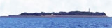

Kotada Bluff (W India)
8.9nm
239°
During W winds, boats can land on the NE side of the bluff.
29 Feb 12
Jojo
| Latitude | Longitude | |
| DMS | --- | --- |
| DM | --- | --- |
| DD | --- | --- |

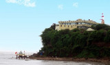
 Gopnath Point, the W entrance point of the Gulf of Cambay, is moderately high, with a conspicuous light structure and bungalow on it. A temple, 23m high, lies near the coast, about 0.8 mile N of the point.
A reef, which dries 2.7m, extends about 1.5 miles ENE from Gopnath Point.
Gopnath Shoals, nearly steep-to on the E side, extend about 3.5 miles NNE from about 2 miles ENE of Gopnath Point. The shoals consist of a reef, which dries from 1.2 to 2.7m, and several patches with depths of less than 5.5m.
Sultanpur Shoals extend about 4 miles NNE from the N end of Gopnath Shoals to about 9 miles NNE of Gopnath Point, then W to the coast. These shoals consist of drying rock, sand and clay, and numerous patches with depths of 0.6 to 5.5m.
Within Gopnath Shoal and Sultanpur Shoal the flood current at springs does not turn until more than 1 hour after the time of HW, and the ebb current continues to run for more than 1.5 hours after the tide has commenced rising.
At neaps the flood current turns 2 hours after the time of HW.
Ebook | Arabian Sea
|