Jaigarh Bay (W India)

Jaigarh Bay (W India)

Pour géolocaliser ce lieu. Mettre à jour si besoin.

Localisation

Jaigarh Bay (W India)
LatitudeLongitude
DMS------
DM------
DD------

Caractéristiques

Mouillage

Description

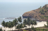
Jaigarh Bay is entered between Jaigarh Head and Bhandarawadi Point, about 1.8 miles NE.
The estuary of the Shastri River, which flows into the head of the bay, forms a sheltered, convenient harbor, fairly easy to access, even during the Southwest Monsoon, for vessels of about 3.4m draft with local knowledge.

The bar of the Shastri River extends NNE from close W of Jaigarh Fort to close E of Katane Reef, which dries 0.6m about 0.2 mile SW of Bhandarawadi Point.

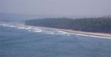
A channel leads E across the S end of the bar about 0.2 mile offshore and had a least depth of 3.7m in 1964, but it is subject to change.

Mora Sands, which dry 1.2m, extend about 0.6 mile W of the NE entrance point of the Shastri River, leaving a navigable channel about 183m wide between Mora Sands and Jaigarh.

Caution.—Vessels approaching Jaigarh Bay from the S should not close Karhateshwar Point within 0.3 mile to avoid foul ground.

2012/03/2
Mettre à jour
Jojo
Ebook

Arabian Sea

  • 132 sites
  • 73 photos
  • publication date: 6 Jul 2023
  • .pdf file size: 49 Mb
Partagez vos remarques ou photos sur "Jaigarh Bay (W India)"

Sites autour de Jaigarh Bay (W India)

Flying distances - Direct line

Jaigarh Head (W India)

1.6nm
250°
Jaigarh Head has Karateshwar Point at its NW extremity; this point appears from seaward to be a level and almost barren plateau terminating in steep rocky cliffs. A Hindu temple stands on the steep face of the cliffs. Jaigarh Head has been reported to be a good radar target at 20 ...
2 Mar 12
Jojo

Boria Bay (W India)

4.4nm
351°
Boria Bay lies SE of Boria Headland. Anchorage, sheltered from NW winds, may be obtained by small vessels, in a depth of 8m, mud.
The coast between Boria Headland and Bhandarawadi Point, 3.5 miles SSE, is composed of small, sandy bays divided by rocky points.
2 Mar 12
Jojo

Warori Bluff anchorage (W India)

6.2nm
167°
A sheltered anchorage, during the Southwest Monsoon, can be odtain on the N side of Warori Bluff, in 5,5 m.
2 Mar 12
Jojo

Warori Bluff point (W India)

6.7nm
170°
Warori Bluff, about 4.5 miles SSE of Ambwah Point, is a conspicuous promontory, 70m high. A light is shown about 0.5 mile SE of the W extremity of Warori Bluff. Good radar returns have been reported from Warori Bluff at 17 miles.
2 Mar 12
Jojo

Kalabadevi Bay (W India)

15nm
167°
Kalbadevi Bay is entered between Sookana Point and Kurne Point.Anchorage may be obtained, in 8m, about 0.7 mile E of Sookana Point and 0.3 mile offshore. Local vessels call here during the Southwest Monsoon.
2 Mar 12
Jojo

Vada Mirya (Mirya Donghur) (W India)

16nm
170°
Vada Mirya (Mirya Donghur), a high rocky headland, is lighter in color than the adjacent coast, and resembles an island when seen from the N or S. The W end of the headland terminates in steep cliffs. Mirya Peak, 142m high, the conspicuous summit of this headland, lies about 0.5 mile ...
2 Mar 12
Jojo