Gulf of Martaban (Burma)

Gulf of Martaban (Burma)

Pour géolocaliser ce lieu. Mettre à jour si besoin.

Localisation

Gulf of Martaban (Burma)
LatitudeLongitude
DMS------
DM------
DD------

Caractéristiques

Mer

Description

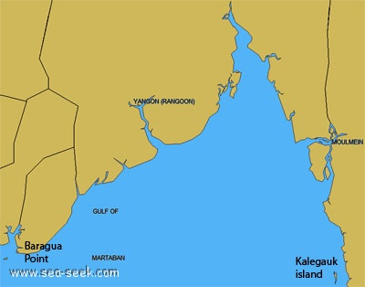
The Gulf of Martaban is entered between Baragua Point and the coast extending N abreast of Kalegauk Island, about 140 miles to the E.
The Sittang River flows into the head of the gulf, about 75 miles N of the entrance. The Rangoon River and the Moulmein River enter the sea on the NW and E sides, respectively, of the gulf.
The entire area of the gulf is shallow and anchorage can be taken anywhere with a suitable draft, but prior to anchoring the direction of the tidal current should be noted and very little chain veered until the vessel stems it.

In 1981, a dangerous wreck was reported to lie in position 15°20'20"N, 96°36'12"E, about 60 miles SSE of Rangoon River Western Channel Entrance.
In 1985, natural gas was discovered in large quantities up to 100 miles offshore in the Gulf of Martaban.
2011/11/21
Mettre à jour
Jojo
Gulf of Martaban (Burma)
2011-11-21
Mettre à jour
Jojo
Ebook

Andaman sea

  • 178 sites
  • 164 photos
  • publication date: 7 Jul 2023
  • .pdf file size: 54 Mb
Partagez vos remarques ou photos sur "Gulf of Martaban (Burma)"

Sites autour de Gulf of Martaban (Burma)

Flying distances - Direct line

Cape Negrais (Burma)

148nm
259°
Cape Negrais, the seaward extremity of a spur of the Arakan Yoma range, in the Bay of Bengal, is fronted by conspicuous cliffs which rise about 0.8 mile inland to a high summit. The cape has been reported to be a good radar target up to 24 miles.
The coast between Cape Negrais ...
21 Nov 11
Jojo

Mawdin Point (Burma)

147nm
257°
Mawdin Point (Pagoda Point), about 30m high and flat, terminates in a bare bluff.
A pagoda lies on the point and is visible above the trees.
A small 2.7m high obelisk lies on the reef on the SE extremity of Mawdin Point.
A shoal, with depths of 5.5m and less, lies up to 0.5 ...
15 Dec 11
Jojo

Racer Marina Huahin

308nm
142°
Racer Marina is the only fully equipped Marina on the east coast of the Gulf of Thailand. Maintenance service, wet berths, hardstand berths. We also have a 35 tons marine travel lift. Visit our website for more information. www.racer-marina.com
18 Jun 17

Laem Chabang

315nm
130°
Port protégé par une digue.
10 Jan 13
KyotoMelody

Sattahip

333nm
133°
Port de commerce protégé par une digue.
10 Jan 13
xxcATTIexx