Teluk Kruengraya is deep for anchorage and the bottom on the W side of the bay is foul. However, Teluk Kruengraya does provide the only anchorage on the N coast of Sumatera that is usually free from swell in both monsoons.
The recommended position is at the head of the bay, 0.3 mile offshore, in a depth of 32m. Temporary anchorage may be obtained on the 10m coral patch.
Pulau Nasi (Peunasoe or Aceh island), nearly joins the SE point of Pulau Breueh, being separated by Aroih Lam Puyang. The coast line is rocky in places with sandy beaches chiefly on the W side.
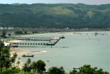
The flat swamp shore only attains any considerable breadth on the W and S sides of Teluk Kruengraya (Krung Raya Bay.Kruengraya (Malahayati Port) has one concrete jetty in good condition. Krueng Raya has for centuries enjoyed renown as a busy fishing port.
People from various important ...
Ujung Bateeputeh (Batu Putih) lying 10.5 miles E of Ujung Baka, is formed of chalk and sandstone, falls steeply to the sea and is easily recognized by a large white patch showing up on green land. A 16 m skeletal tower, painted white is located on a promontory facing the Ombai ...
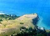
Ujung Baka (Pedro point or Pedropunt), is the N point of Sumatera. The appearance of the coast has changes at Ujung Baka. W of it the coast is flat, but eastward it is hilly.
Lhok Prialaut is the bay lying between Ug Bau and Ug Seukundo. 6,5 NM appart, between wich points the bay extends S for about 4 NM, with Teluk Sabang on its E shore. Lhok Prialaut is about 2 miles in length and breadth, with good anchorage near its head, in 16.5 to 21.9m. Tides—Currents.—The ...
Pulau Buro, a rocky cone-shaped island, lies in Sempitan Malaka (Malacca Passage), about 4 miles WNW of Ujung Baka (Pedropunt). Caution is necessary when approaching the island during light winds, as the tidal currents set strongly over the surrounding reef. A light is shown from the island.


 Teluk Kruengraya is deep for anchorage and the bottom on the W side of the bay is foul. However, Teluk Kruengraya does provide the only anchorage on the N coast of Sumatera that is usually free from swell in both monsoons.
")
")