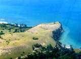
Pulau Peunasoe (Nasi) (SE Breueh)
22nm
273°
The coast line is rocky in places with sandy beaches chiefly on the W side.
11 Jan 12
Jojo
| Latitude | Longitude | |
| DMS | --- | --- |
| DM | --- | --- |
| DD | --- | --- |

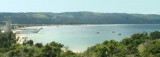
 The flat swamp shore only attains any considerable breadth on the W and S sides of Teluk Kruengraya (Krung Raya Bay.
Kruengraya (Malahayati Port) has one concrete jetty in good condition.
Krueng Raya has for centuries enjoyed renown as a busy fishing port.
People from various important places in the world such as Kota Raja in
Banda Aceh and Gujarat in India called on the port.
Krueng Raya is known as Aceh’s “capital” of teri nasi (tiny sea fish). In the bay, the delicious tiny fish are caught, boiled, sun-dried and then loaded onto trucks to be delivered to Banda Aceh, Medan and even Jakarta.
Depths—Limitations.—The T-head jetty is 100m long and 15m wide, with a depth of 6.7m alongside. There is a mooring dolphin on each side of the jetty head. A connecting bridge extends 100m from the shore to the T-head. One vessel up to 10,000 dwt, with a length of 80m and a draft of 8m, can be accommodated.
")
")
")
Ebook | Andaman sea
|