The coast of Sumatera (Sumatra) from Batakarang Point trends NNW for about 65 miles to Tanjung Jabung. The entire coast is very low, covered with wood, and fronted by a mud bank that, within a depth of 9.1m, in places, extends about 13 miles offshore. It may be approached to ...
Pulau Saya, located about 30 miles NW of Pulau-pulau Tuju, is steep-to, of granite formation, covered with wood, and has a double-peaked 210m high summit; the N peak is about 18.3m less in elevation than the S one, and both peaks are in range on a 180° and opposite bearing. A ...
Pulau Bujang, about 5 miles W of Pulau Selentang, is hilly and wooded, with a peaked hill 111m high near its center; it is steep-to on the NE side but elsewhere is surrounded by a reef which dries. On the SE side, are two wooded rocks. Tjawan Reef, which dries, lies about 0.5 mile ...
Kepulauan Singkeplaut (Singkep Laoet Islands), lying on a drying reef E of Tanjung Buku and fronting Teluk Baruk, consists of Pulau Keling, Pulau Tengah, Pulau Lalang, and Pulau Singkeplaut, as well as a few abovewater rocks. A conspicuous tree is reported to stand on Pulau Singkeplaut.
Tanjung Jabung (Djaboong), the SW limit of the Inner Route (N Singapore Strait from Selat Bangka via Selat Berhala and Selat Durian), is conspicious and partly overgrown with trees. Like most other parts of the Eastern coast of Sumatera, it is low land and is fronted by a mud bank ...
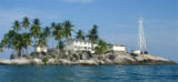
Pulau Berhala is a rocky island largely covered with high trees. Two bare peaks, each 91m high, rise on the W side of the island; the island is inhabited. It lies in the middle of Selat Berhala, nearly between Tanjung Jabung and Tanjung Buku, the SW end of Pulau Singkep. Except on ...


 Petit port .
 Small port .