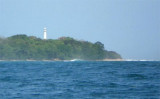
Pulau Pisang, quartz rock, 41m high and densely overgrown with coconut palms, is almost 1 mile in extent and lies about 11 miles SE of Teluk Pugung and I mile offshore; the intermediate coast is steep-to. It is surrounded by a narrow coastal reef with deep water about 0.2 mile off, with the exception of the NE side, where it is connected to the mainland by a ledge with a greatest depth of 73m. On this ledge and to the N of the island, are patches with depths from 1.8 to 5.5m.
Ujung Cukubatuberagam the, S extremity of the bay, is fringed by a coral reef; a 3.6m patch lies 0.5 mile N of the point and a shoal, upon which there is a rock with a depth of 0.6m, lies 1.5 miles NNW of the point. The coast from Ujung Cukubatuberagam trends about 23 miles SE ...
Pulau Batu Kecil lies about 7 miles WNW of Tanjung Balimbingpamancasa; it is low, wooded,about 0.7 mile in extent, and surrounded by a reef. A shoal bank extends NW and SE of the island.
Tg Balimbing (Belimbing) is the S point of Teluk Balimbing and the NW entrance point of Selat Sunda. The coast is generally low and densely overgrown, but inland the country is mountainous.Teluk Balimbing indents the coast just N of Tanjung Balimbingpamancasa. The village of Balimbing ...
Off Tg Manna during the E Monsson period, heavy rollers get up in 7.3m, and a break may occur in depths of 5.5m after the sea breeze sets in, thus preventing any communication with the shore. It is therefore not a desirable anchorage.
Pulau Dua is inhabited and covered with trees; except for a small opening on the W side, it is surrounded by a coral reef of considerable extent, partly dry at LW, but having depths of 7.3 to 18.3m close-to.
Teluk Enggano (Engano Bay), the principal anchorage, is on the E side of the island, and has in its entrance three small islands surrounded by reefs, which always break heavily.


 Pulau Pisang, quartz rock, 41m high and densely overgrown with coconut palms, is almost 1 mile in extent and lies about 11 miles SE of Teluk Pugung and I mile offshore; the intermediate coast is steep-to.